IMAGES TAKEN NEAR TO
Claypole Lane, NEWARK, NG23 5HZ
Introduction
This page details the photographs taken nearby to Claypole Lane, NG23 5HZ by members of the Geograph project.
The Geograph project started in 2005 with the aim of publishing, organising and preserving representative images for every square kilometre of Great Britain, Ireland and the Isle of Man.

There are currently over 7.5m images from over14,400 individuals and you can help contribute to the project by visiting https://www.geograph.org.uk
Image Map
Images are licensed for reuse under creativecommons.org/licenses/by-sa/2.0
Notes
- Clicking on the map will re-center to the selected point.
- The higher the marker number, the further away the image location is from the centre of the postcode.
Image Listing (54 Images Found)
Images are licensed for reuse under creativecommons.org/licenses/by-sa/2.0
Image
Details
Distance
1
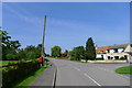
Main Street, Dry Doddington
At the junction with Claypole Lane
Image: © Tim Heaton
Taken: 1 Jun 2014
0.06 miles
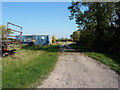
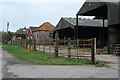
3
Farmyard and the beginning of a footpath
Image: © Jonathan Thacker
Taken: 22 Oct 2010
0.10 miles
4
Dry Doddington, Lincolnshire.
The village is so named, not, as you can see, because of its lack of pubs, for there is the excellent Wheatsheaf Inn on the right of the picture. But the name derives from ancient times when the land was the "dry" estate of a man named Dodda. The 600 year old church of St. James was restored in 1876 and is noted for its leaning tower and spire. See also Image The church contains a memorial to two members of the crew of a 49 Squadron Lancaster bomber which crashed nearby in November 1944. It was heavily laden with bombs and fuel having just taken off from the local RAF Bomber Command station. It was a miracle that the other five crew members survived the crash.
Image: © Derek Voller
Taken: 24 Feb 2011
0.10 miles
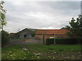
5
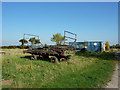
Long Lane farm
A rusting trailer by Long Lane
Image: © Richard Croft
Taken: 30 Sep 2011
0.11 miles
6
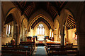
St.James' nave
View east in St.James' nave with late 13th century arcades
Image: © Richard Croft
Taken: 3 Feb 2017
0.12 miles
7
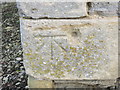
Ordnance Survey Cut Mark with Bolt (missing)
This can be found on the tower wall of St James Church.
For more detail see : http://www.bench-marks.org.uk/bm25086
Image: © Peter Wood
Taken: 4 Mar 2014
0.12 miles
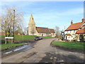
9
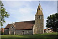
Dry Doddington church
Dry Doddington church is dedicated to St James. The church tower and spire lists significantly.
Image: © Philip Halling
Taken: 30 Jun 2013
0.12 miles
10
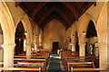
St.James' nave
View west in St.James' church with late 13th century arcades and a humble doorway to the 14th century tower
Image: © Richard Croft
Taken: 3 Feb 2017
0.12 miles