IMAGES TAKEN NEAR TO
Town Street, NEWARK, NG23 5HJ
Introduction
This page details the photographs taken nearby to Town Street, NG23 5HJ by members of the Geograph project.
The Geograph project started in 2005 with the aim of publishing, organising and preserving representative images for every square kilometre of Great Britain, Ireland and the Isle of Man.

There are currently over 7.5m images from over14,400 individuals and you can help contribute to the project by visiting https://www.geograph.org.uk
Image Map
Images are licensed for reuse under creativecommons.org/licenses/by-sa/2.0
Notes
- Clicking on the map will re-center to the selected point.
- The higher the marker number, the further away the image location is from the centre of the postcode.
Image Listing (59 Images Found)
Images are licensed for reuse under creativecommons.org/licenses/by-sa/2.0
Image
Details
Distance
2
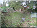
Ditch in Westborough
The village is bisected by this ditch which at least has the virtue of not being filled with rubbish as would surely be its fate in a larger settlement.
Image: © Jonathan Thacker
Taken: 22 Oct 2010
0.02 miles
3
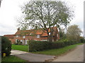
Cottages in Westborough
Many buildings in Westborough exhibit lias stone walling. This stone is poor by comparison with the limestones of only a few miles away. Other examples of its use can be found in several villages around Newark on Trent including Collingham, Langford, Dry Doddington and Long Bennington.
Image: © Jonathan Thacker
Taken: 22 Oct 2010
0.03 miles
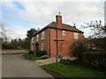
4
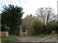
The Old Rectory, Westborough
The oldest parts date to the sixteenth century, though the bulk of the building dates from the eighteenth century https://historicengland.org.uk/listing/the-list/list-entry/1253451
Image: © Jonathan Thacker
Taken: 15 Mar 2021
0.04 miles
5
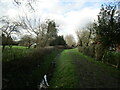
Back Lane, Westborough
A bridleway.
Image: © Jonathan Thacker
Taken: 15 Mar 2021
0.05 miles
7
Back Lane, Westborough
Attached to a tree in the lane is a memorial to six crew-members of a Lancaster bomber who were killed when their aircraft crashed here on 15th January 1945.
https://www.geograph.org.uk/photo/6502780
Image: © Adrian S Pye
Taken: 8 Jun 2020
0.07 miles
8
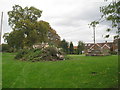
Bonfire and base of Market Cross
Still two weeks to go until bonfire night and the folks of Westborough have already built an impressive pile.
Image: © Jonathan Thacker
Taken: 22 Oct 2010
0.07 miles
9
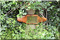
Almost hidden by the goosegrass
Memorial plaque remembers those killed in the crash of Lancaster LM619 of 1668 HCU (Heavy Conversion Unit) which crashed near here on 15th January 1945.
Pilot; Flg Off. Ivan Lindsay THOMPSON, age 23
Flight Engineer; Flt Sgt. James RAWLINSON, age 19
Navigator; Sgt. John Gordon HAZELDEN, age 21
Wireless Operator; Flt Sgt. Allen Benjamin THOMAS, age 22
Bomb Aimer; Sgt. Cyril Reuben Clifford MANN, age 23
Air Gunner; Sgt. Dennis Gilbert BURN, age 23
Air Gunner; Sgt G F Ashby was injured but survived.
Under normal circumstances the local Drainage Board maintain the watercourse, above which the memorial is located, but due to the current Covid 19 restrictions the work has not been carried out.
Image: © Adrian S Pye
Taken: 8 Jun 2020
0.07 miles
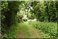
10
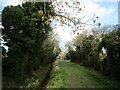
Back Lane, Westborough
A bridleway.
Image: © Jonathan Thacker
Taken: 15 Mar 2021
0.07 miles