IMAGES TAKEN NEAR TO
Main Street, NEWARK, NG23 5GQ
Introduction
This page details the photographs taken nearby to Main Street, NG23 5GQ by members of the Geograph project.
The Geograph project started in 2005 with the aim of publishing, organising and preserving representative images for every square kilometre of Great Britain, Ireland and the Isle of Man.

There are currently over 7.5m images from over14,400 individuals and you can help contribute to the project by visiting https://www.geograph.org.uk
Image Map
Images are licensed for reuse under creativecommons.org/licenses/by-sa/2.0
Notes
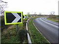
- Clicking on the map will re-center to the selected point.
- The higher the marker number, the further away the image location is from the centre of the postcode.
Image Listing (9 Images Found)
Images are licensed for reuse under creativecommons.org/licenses/by-sa/2.0
Image
Details
Distance
1
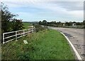
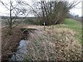
Battle Bridge near Upton
Bridge on the A612 road near Upton. It traverses a minor brook and is nondescript in appearance yet has an interesting name. Conventional wisdom points to a Civil War origin; however a look at the 1820 Survey of the Trent clearly shows it to be called 'Bartle Bridge' and the name remains the same on the OS First Series sheet (70) from 1856.
Image: © Jonathan Clitheroe
Taken: 18 Oct 2023
0.08 miles
2
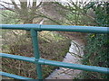
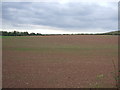
Stream from A612 roadside
0.5Km NE of Upton
Image: © Colin Bland
Taken: 31 Dec 2006
0.09 miles
4
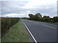
A612 near Upton village
About 0.5Km NE of Upton
Image: © Colin Bland
Taken: 31 Dec 2006
0.10 miles
6
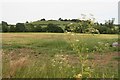
Bridge to Micklebarrow Hill
Carrying the Trent Valley Way from Upton (right) to Micklebarrow Hill (left).
Image: © Tim Heaton
Taken: 30 Dec 2008
0.24 miles
7
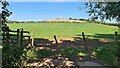
Hemlock next to footpath to Micklebarrow Hill
Micklebarrow Hill in Image
Image: © Chris
Taken: 23 Jun 2018
0.24 miles
9
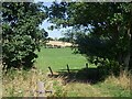
Looking over a stream to a herd of cattle
Image: © Graham Hogg
Taken: 23 Aug 2021
0.25 miles