IMAGES TAKEN NEAR TO
The Parklands, NEWARK, NG23 5GL
Introduction
This page details the photographs taken nearby to The Parklands, NG23 5GL by members of the Geograph project.
The Geograph project started in 2005 with the aim of publishing, organising and preserving representative images for every square kilometre of Great Britain, Ireland and the Isle of Man.

There are currently over 7.5m images from over14,400 individuals and you can help contribute to the project by visiting https://www.geograph.org.uk
Image Map
Images are licensed for reuse under creativecommons.org/licenses/by-sa/2.0
Notes
- Clicking on the map will re-center to the selected point.
- The higher the marker number, the further away the image location is from the centre of the postcode.
Image Listing (23 Images Found)
Images are licensed for reuse under creativecommons.org/licenses/by-sa/2.0
Image
Details
Distance
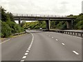
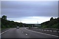
1
Flyover
Costa Row crossing the A1 at Long Bennington
Image: © Richard Croft
Taken: 14 Aug 2008
0.10 miles
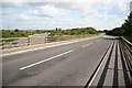
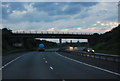
3
A1 at Long Bennington, Costa Row Overbridge
Image: © David Dixon
Taken: 4 Aug 2014
0.12 miles
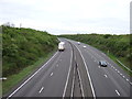
6
A1 - bridge at Long Bennington
The road over is called Costa Row.
Image: © Robin Webster
Taken: 7 Oct 2011
0.12 miles
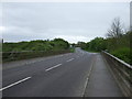
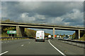
8
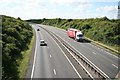
A1 traffic
Looking south on the A1 from Costa Row bridge at Long Bennington
Image: © Richard Croft
Taken: 14 Aug 2008
0.14 miles