IMAGES TAKEN NEAR TO
Kirtons Lane, NEWARK, NG23 5DX
Introduction
This page details the photographs taken nearby to Kirtons Lane, NG23 5DX by members of the Geograph project.
The Geograph project started in 2005 with the aim of publishing, organising and preserving representative images for every square kilometre of Great Britain, Ireland and the Isle of Man.

There are currently over 7.5m images from over14,400 individuals and you can help contribute to the project by visiting https://www.geograph.org.uk
Image Map
Images are licensed for reuse under creativecommons.org/licenses/by-sa/2.0
Notes
- Clicking on the map will re-center to the selected point.
- The higher the marker number, the further away the image location is from the centre of the postcode.
Image Listing (21 Images Found)
Images are licensed for reuse under creativecommons.org/licenses/by-sa/2.0
Image
Details
Distance
3
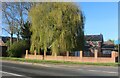
Willow tree on Main Road, Long Bennington
Image: © David Howard
Taken: 7 May 2023
0.07 miles
5
House in Long Bennington
Many buildings in Long Bennington exhibit lias stone walling. This former farmhouse is typical in that the stone walling is confined to the ground floor. This stone is poor by comparison with the limestones of only a few miles away. Other examples of its use can be found in several villages around Newark on Trent including Collingham, Langford, Dry Doddington and Westborough
Image: © Jonathan Thacker
Taken: 22 Oct 2010
0.10 miles
6
Cottages in Long Bennington
Many buildings in Long Bennington exhibit lias stone walling but usually as in this case only at ground floor level. This stone is poor by comparison with the limestones of only a few miles away. Other examples of its use can be found in several villages around Newark on Trent including Collingham, Langford, Dry Doddington and Westborough
Image: © Jonathan Thacker
Taken: 22 Oct 2010
0.10 miles
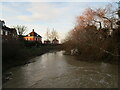
7

River Witham
Looking north-west with new housing at Long Bennington
Image: © Richard Croft
Taken: 5 May 2006
0.11 miles
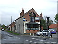
9
The Wheatsheaf, Long Bennington
Many buildings in Long Bennington exhibit lias stone walling though rarely to the full height of the building as here. This stone is poor by comparison with the limestones of only a few miles away. Other examples of its use can be found in several villages around Newark on Trent including Collingham, Langford, Dry Doddington and Westborough.
Image: © Jonathan Thacker
Taken: 22 Oct 2010
0.13 miles
10
The River Witham in flood at Long Bennington
Image: © Jonathan Thacker
Taken: 27 Dec 2020
0.15 miles