IMAGES TAKEN NEAR TO
Oster Fen Lane, NEWARK, NG23 5AS
Introduction
This page details the photographs taken nearby to Oster Fen Lane, NG23 5AS by members of the Geograph project.
The Geograph project started in 2005 with the aim of publishing, organising and preserving representative images for every square kilometre of Great Britain, Ireland and the Isle of Man.

There are currently over 7.5m images from over14,400 individuals and you can help contribute to the project by visiting https://www.geograph.org.uk
Image Map
Images are licensed for reuse under creativecommons.org/licenses/by-sa/2.0
Notes
- Clicking on the map will re-center to the selected point.
- The higher the marker number, the further away the image location is from the centre of the postcode.
Image Listing (6 Images Found)
Images are licensed for reuse under creativecommons.org/licenses/by-sa/2.0
Image
Details
Distance
1
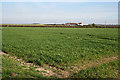
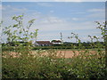
Claypole Fen, Lincolnshire
Blackmires Farm, which is more or less at the centre of the featured square, is on the horizon. The low hills behind are the start of the wolds countryside in South Kesteven.
Image: © Kate Jewell
Taken: 5 Apr 2007
0.01 miles
5
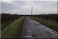
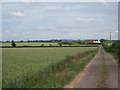
Road to Fen Farm
At the end of Oster Fen Lane.
Image: © J.Hannan-Briggs
Taken: 15 Dec 2013
0.21 miles
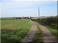
6
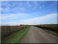
Road to Fen Farm
As boy I used to help drive cattle to Fen Farm but usually along the dykes rather than along the tracks.
Image: © Jonathan Thacker
Taken: 22 Mar 2020
0.23 miles