IMAGES TAKEN NEAR TO
Shire Lane, NEWARK, NG23 5AQ
Introduction
This page details the photographs taken nearby to Shire Lane, NG23 5AQ by members of the Geograph project.
The Geograph project started in 2005 with the aim of publishing, organising and preserving representative images for every square kilometre of Great Britain, Ireland and the Isle of Man.

There are currently over 7.5m images from over14,400 individuals and you can help contribute to the project by visiting https://www.geograph.org.uk
Image Map
Images are licensed for reuse under creativecommons.org/licenses/by-sa/2.0
Notes
- Clicking on the map will re-center to the selected point.
- The higher the marker number, the further away the image location is from the centre of the postcode.
Image Listing (4 Images Found)
Images are licensed for reuse under creativecommons.org/licenses/by-sa/2.0
Image
Details
Distance
1
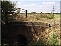
Ditch Bridge
This bridge carries farm traffic into the fields beyond this land drain.
Image: © Michael Patterson
Taken: 28 Jul 2006
0.20 miles
2
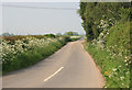
Broad Fen lane
May hedge rows look nice in the sun with the blossom.
Image: © roger geach
Taken: 24 May 2012
0.22 miles
4
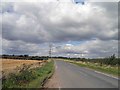
Shire Lane near Claypole
In the distance yet another pylon.
Image: © Steve Fareham
Taken: 11 Sep 2012
0.25 miles