IMAGES TAKEN NEAR TO
Oxbow Close, NOTTINGHAM, NG2 2NN
Introduction
This page details the photographs taken nearby to Oxbow Close, NG2 2NN by members of the Geograph project.
The Geograph project started in 2005 with the aim of publishing, organising and preserving representative images for every square kilometre of Great Britain, Ireland and the Isle of Man.

There are currently over 7.5m images from over14,400 individuals and you can help contribute to the project by visiting https://www.geograph.org.uk
Image Map
Images are licensed for reuse under creativecommons.org/licenses/by-sa/2.0
Notes
- Clicking on the map will re-center to the selected point.
- The higher the marker number, the further away the image location is from the centre of the postcode.
Image Listing (345 Images Found)
Images are licensed for reuse under creativecommons.org/licenses/by-sa/2.0
Image
Details
Distance
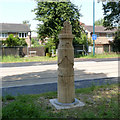
1

Queen's Walk: tram sign and story pole
Signs are going up now the tramway extension is nearing completion. The story pole recalls the industrial heritage of The Meadows, combining Nottingham lace and the headstocks of Clifton Colliery, which was once nearby. The houses in the background date from the redevelopment of The Meadows in the 1970s. They stand on the edge of what was once the Great Central Railway goods yards.
Image: © John Sutton
Taken: 26 Aug 2014
0.06 miles
2
Story Pole 8: Industry. Near Doyne Court
An alternative angle to my previous view http://www.geograph.org.uk/photo/4087769
and in better lighting conditions.
Image: © Alan Murray-Rust
Taken: 31 Aug 2014
0.06 miles
3
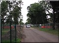
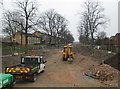
Queen's Walk: tramway construction site
The majority of the southern half of Queen's Walk is now fenced off. This picture was taken through gates opened to let the lorry out.
Image: © John Sutton
Taken: 12 Sep 2012
0.07 miles
4
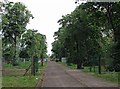
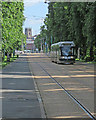
Queen's Walk: the tram route
Looking towards the city, with the tower of St Mary's Church in the Lace Market a focal point in the distance.
Image: © John Sutton
Taken: 18 Aug 2012
0.07 miles
5
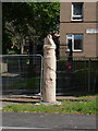
Story pole 8: Industry
Featuring a colliery headstocks and underground workers, and Nottingham lace.
Image: © Alan Murray-Rust
Taken: 23 Jul 2014
0.07 miles
6
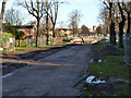
Queen's Walk: Robin Hood Way to the Trent
The subway under Robin Hood Way has been filled in and the land in the foreground levelled. The tramway will cross Robin Hood Way on the level.
Image: © John Sutton
Taken: 11 Apr 2013
0.07 miles
7
A Clifton tram in Queen's Walk
A foreshortened telephoto shot, looking towards Meadows Way and, in the distance, Nottingham Station and the tower of St Mary's Church in the Lace Market.
Image: © John Sutton
Taken: 4 Jun 2017
0.07 miles
8

Cyclist and tram on Queen's Walk
A foreshortened telephoto shot, looking towards Meadows Way and, in the distance, Nottingham Station and the tower of St Mary's Church in the Lace Market.
Image: © John Sutton
Taken: 4 Jun 2017
0.07 miles
9
Queens Walk at Robin Hood Way
The initial work on services is largely complete. The next phase will be the filling in of the subway.
Image: © Alan Murray-Rust
Taken: 23 Nov 2012
0.07 miles
10
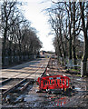
Tracks in place from Robin Hood Way to the Toll Bridge
A slightly foreshortened zoom shot of the southern section of Queen's Walk. In the foreground the tracks rise to where they will cross Robin Hood Way on the level. Work has yet to begin on the crossing itself.
Image: © John Sutton
Taken: 8 Feb 2014
0.07 miles