IMAGES TAKEN NEAR TO
Osier Road, NOTTINGHAM, NG2 2NL
Introduction
This page details the photographs taken nearby to Osier Road, NG2 2NL by members of the Geograph project.
The Geograph project started in 2005 with the aim of publishing, organising and preserving representative images for every square kilometre of Great Britain, Ireland and the Isle of Man.

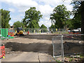
There are currently over 7.5m images from over14,400 individuals and you can help contribute to the project by visiting https://www.geograph.org.uk
Image Map
Images are licensed for reuse under creativecommons.org/licenses/by-sa/2.0
Notes
- Clicking on the map will re-center to the selected point.
- The higher the marker number, the further away the image location is from the centre of the postcode.
Image Listing (242 Images Found)
Images are licensed for reuse under creativecommons.org/licenses/by-sa/2.0
Image
Details
Distance
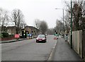
1
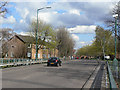
Robin Hood Way
One of the main distributor roads created as part of the redevelopment of the Meadows during the 1970s. The new road layout bore no relation to the old mass of terraced streets.
Image: © Alan Murray-Rust
Taken: 7 Apr 2009
0.06 miles
2
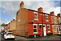
Glapton Road houses at Barnsley Terrace junction
There is an Ordnance Survey benchmark Image on the side of the house at the corner at the junction of the house and its side wall
Image: © Luke Shaw
Taken: 11 May 2019
0.08 miles
3
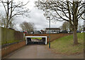
Pedestrian underpass under Robin Hood Way, Nottingham
Image: © habiloid
Taken: 17 Feb 2023
0.08 miles
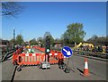
4
Robin Hood Way crossing
Tracks have been laid to the mid point of the carriageway.
Image: © Alan Murray-Rust
Taken: 7 Mar 2014
0.08 miles
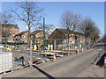
5
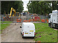
View of the works
Looking south from Robin Hood Way above the now-closed subway. There has been quite a change even in the 4 days since this http://www.geograph.org.uk/photo/3088738 was taken.
Image: © Alan Murray-Rust
Taken: 23 Aug 2012
0.08 miles
6

Queen's Walk: Robin Hood Way underpass
The subway is to be filled in and the Clifton tram line and the cycle track will cross Robin Hood Way on the level.
Image: © John Sutton
Taken: 20 Jul 2012
0.08 miles
7
Queens Walk subway bridge
This will be removed and the subway filled in to allow the tramway to cross the road on the level.
Image: © Alan Murray-Rust
Taken: 23 Nov 2012
0.08 miles
8
Temporary traffic lights on Robin Hood Way
The car has just crossed the filled-in subway which took Queen's Walk under Robin Hood Way. The land is being levelled and the Clifton tram line will cross here. (The lights must have changed as I pressed the shutter - they were red as I framed the picture.)
Image: © John Sutton
Taken: 12 Apr 2013
0.08 miles
9
Tramway works at Robin Hood Way
The contractors are preparing to remove the road surface and lay a concrete slab to carry the Clifton tram line over the former pedestrian subway, which has been filled. The tram line along Queen's Walk will rise either side of Robin Hood way to cross it on the level.
Image: © John Sutton
Taken: 2 May 2013
0.08 miles
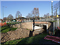
10
Site of the pedestrian subway at Robin Hood Way
The road will have to be lowered to allow the tramway to pass, so there is still a lot of work to do here.
Image: © Alan Murray-Rust
Taken: 26 Jul 2013
0.08 miles