IMAGES TAKEN NEAR TO
Aldermens Close, NOTTINGHAM, NG2 2NJ
Introduction
This page details the photographs taken nearby to Aldermens Close, NG2 2NJ by members of the Geograph project.
The Geograph project started in 2005 with the aim of publishing, organising and preserving representative images for every square kilometre of Great Britain, Ireland and the Isle of Man.

There are currently over 7.5m images from over14,400 individuals and you can help contribute to the project by visiting https://www.geograph.org.uk
Image Map
Images are licensed for reuse under creativecommons.org/licenses/by-sa/2.0
Notes
- Clicking on the map will re-center to the selected point.
- The higher the marker number, the further away the image location is from the centre of the postcode.
Image Listing (288 Images Found)
Images are licensed for reuse under creativecommons.org/licenses/by-sa/2.0
Image
Details
Distance
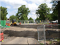
1
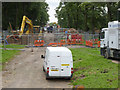
View of the works
Looking south from Robin Hood Way above the now-closed subway. There has been quite a change even in the 4 days since this http://www.geograph.org.uk/photo/3088738 was taken.
Image: © Alan Murray-Rust
Taken: 23 Aug 2012
0.05 miles
2

Queen's Walk: Robin Hood Way underpass
The subway is to be filled in and the Clifton tram line and the cycle track will cross Robin Hood Way on the level.
Image: © John Sutton
Taken: 20 Jul 2012
0.05 miles
3
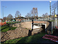
Queens Walk subway bridge
This will be removed and the subway filled in to allow the tramway to cross the road on the level.
Image: © Alan Murray-Rust
Taken: 23 Nov 2012
0.05 miles
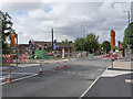
4
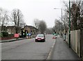
Temporary traffic lights on Robin Hood Way
The car has just crossed the filled-in subway which took Queen's Walk under Robin Hood Way. The land is being levelled and the Clifton tram line will cross here. (The lights must have changed as I pressed the shutter - they were red as I framed the picture.)
Image: © John Sutton
Taken: 12 Apr 2013
0.05 miles
5
Tramway works at Robin Hood Way
The contractors are preparing to remove the road surface and lay a concrete slab to carry the Clifton tram line over the former pedestrian subway, which has been filled. The tram line along Queen's Walk will rise either side of Robin Hood way to cross it on the level.
Image: © John Sutton
Taken: 2 May 2013
0.05 miles
6
Site of the pedestrian subway at Robin Hood Way
The road will have to be lowered to allow the tramway to pass, so there is still a lot of work to do here.
Image: © Alan Murray-Rust
Taken: 26 Jul 2013
0.05 miles
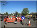
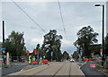
7

Tramway crossing on Robin Hood Way
Trackwork is complete but work on the roadway means that single line working is still required.
Image: © Alan Murray-Rust
Taken: 23 Jun 2014
0.05 miles
8
Robin Hood Way tramway crossing
The tramway is complete through the crossing but there is still work in the carriageway meaning that single-lane working is still in force.
Image: © Alan Murray-Rust
Taken: 14 Aug 2014
0.05 miles
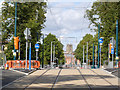
9
Where the trams will cross Robin Hood Way
A view along Queen's Walk towards the city. The tramway rises gently to cross Robin Hood Way. Before the tramway was built there was a pedestrian subway here - see Image], Image], Image] and others. Night-time testing of the trams on this part of the route began in August 2014.
Image: © John Sutton
Taken: 26 Aug 2014
0.05 miles
10
Robin Hood Way tramway crossing
The unfencing of the tramway has opened up some new angles for photography. St Mary's Church is exactly line on the centre of the tramway
Image: © Alan Murray-Rust
Taken: 31 Aug 2014
0.05 miles