IMAGES TAKEN NEAR TO
Blair Court, NOTTINGHAM, NG2 2NB
Introduction
This page details the photographs taken nearby to Blair Court, NG2 2NB by members of the Geograph project.
The Geograph project started in 2005 with the aim of publishing, organising and preserving representative images for every square kilometre of Great Britain, Ireland and the Isle of Man.

There are currently over 7.5m images from over14,400 individuals and you can help contribute to the project by visiting https://www.geograph.org.uk
Image Map
Images are licensed for reuse under creativecommons.org/licenses/by-sa/2.0
Notes
- Clicking on the map will re-center to the selected point.
- The higher the marker number, the further away the image location is from the centre of the postcode.
Image Listing (357 Images Found)
Images are licensed for reuse under creativecommons.org/licenses/by-sa/2.0
Image
Details
Distance
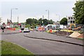
1
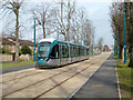
Tram on test, Queens Walk
Between Wilford Bridge and Robin Hood Way
Image: © Alan Murray-Rust
Taken: 11 Mar 2015
0.02 miles
2
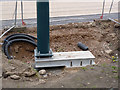
Offset overhead pole
For some reason the foundation for the pole has not been constructed directly below the pole, requiring a special bracket.
Image: © Alan Murray-Rust
Taken: 4 Apr 2014
0.02 miles
3
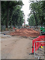
Queen's Walk: preparing the way for the trams
The route is being levelled ready for the concrete trackbase to be laid. The northern end of Wilford Toll Bridge is just visible in the centre.
Image: © John Sutton
Taken: 23 Aug 2013
0.02 miles
4
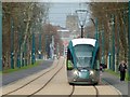
Tram approaching Meadows Embankment stop
The tower of St Mary's Church rises in the distance.
Image: © Alan Murray-Rust
Taken: 20 Mar 2015
0.02 miles
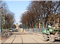
5
Queens Walk tram stop site
More extensive work on services is under way.
Image: © Alan Murray-Rust
Taken: 21 Jun 2012
0.03 miles
6
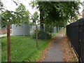
Reduced footway
Much of Queen's Walk has been fenced off for construction work.
Image: © Alan Murray-Rust
Taken: 23 Aug 2012
0.03 miles
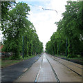
7
Queens Walk
Looking up the tramway towards the City centre.
Image: © Alan Murray-Rust
Taken: 7 Mar 2014
0.03 miles
8
Queen's Walk: waiting for the wires
A view towards the city from just north of where the Queen's Walk tram stop will be. The track, roadway and footpaths are complete and the poles in place, but the wires have yet to be strung.
See Image] for the state of play in August 2012 and Image] for how things were just over a year before.
Image: © John Sutton
Taken: 11 May 2014
0.03 miles
9
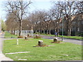
Tree stumps. Queens Walk (2)
At the site of the Queens Walk tram stop.
Image: © Alan Murray-Rust
Taken: 1 Apr 2012
0.03 miles
10
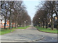
The bottom of Queens Walk
Formerly Queens Drive, and the main way into Nottingham from the south west, even after the closure of Wilford Bridge to traffic. It was some time after that that the current alignment of Queens Drive was created, allowing this attractive avenue to be converted into a pedestrian way. Powered vehicles could again be seen along here in the future as it is earmarked for the propsed Clifton route of the Nottingham tram.
Image: © Alan Murray-Rust
Taken: 20 Mar 2009
0.03 miles