IMAGES TAKEN NEAR TO
Victoria Embankment, NOTTINGHAM, NG2 2JY
Introduction
This page details the photographs taken nearby to Victoria Embankment, NG2 2JY by members of the Geograph project.
The Geograph project started in 2005 with the aim of publishing, organising and preserving representative images for every square kilometre of Great Britain, Ireland and the Isle of Man.

There are currently over 7.5m images from over14,400 individuals and you can help contribute to the project by visiting https://www.geograph.org.uk
Image Map
Images are licensed for reuse under creativecommons.org/licenses/by-sa/2.0
Notes
- Clicking on the map will re-center to the selected point.
- The higher the marker number, the further away the image location is from the centre of the postcode.
Image Listing (532 Images Found)
Images are licensed for reuse under creativecommons.org/licenses/by-sa/2.0
Image
Details
Distance
1
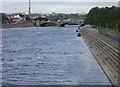
River blue (2)
A lucky combination of overcast and clear patches resulted in the river appearing a really deep blue. No touching up here! Trent Bridge is visible in the distance - seen from Wilford Suspension Bridge.
Image: © Alan Murray-Rust
Taken: 23 Sep 2008
0.05 miles
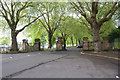
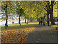
2
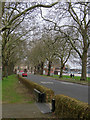
Plane trees on Victoria Embankment
A chilly April morning on Trentside. In the foreground is one of a good number of steel flood gates placed each side of the river in these parts.
Image: © John Sutton
Taken: 7 Apr 2019
0.05 miles
3
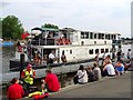
Nottingham Princess at the Riverside Festival 2019
Providing boat trips from the landing stage below Trent Bridge.
Image: © Ian Calderwood
Taken: 3 Aug 2019
0.06 miles
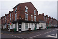
4
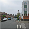
Along Fraser Road
The rather grand houses on the left face Victoria Embankment and the River Trent. On the right is a recent development built on a wedge of land between Fraser Road, Green Street (to the right) and the Memorial Gardens.
Image: © John Sutton
Taken: 7 Apr 2019
0.06 miles
6
Entrance to Victoria Embankment
There is an OS benchmark Image on the right hand side of the rightmost post of the gateway across the embankment road
Image: © Luke Shaw
Taken: 11 May 2019
0.06 miles
7
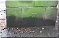
Benchmark on post at entrance to Victoria Embankment
Ordnance Survey cut mark benchmark described on the Bench Mark Database at www.bench-marks.org.uk/bm53054
Image: © Luke Shaw
Taken: 11 May 2019
0.07 miles
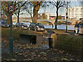
8
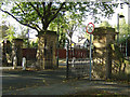
Embankment Gates
The entrance to the Victoria Embankment at the Trent Bridge end.
Image: © Alan Murray-Rust
Taken: 23 Sep 2008
0.07 miles
9
On Victoria Embankment in October
The majority of the people in the picture were making their way home, via the Suspension Bridge, after seeing Notts County beat Barnet 2-1 to return to the top of the fourth-division table.
Image: © John Sutton
Taken: 14 Oct 2017
0.07 miles
10
Flood defence, Victoria Embankment
The wall is a relatively recent addition to flood defences, pierced at intervals by these heavy gates which can be shut if floods are threatened.
Image: © Alan Murray-Rust
Taken: 1 Dec 2013
0.07 miles