IMAGES TAKEN NEAR TO
Wilford Crescent West, NOTTINGHAM, NG2 2FS
Introduction
This page details the photographs taken nearby to Wilford Crescent West, NG2 2FS by members of the Geograph project.
The Geograph project started in 2005 with the aim of publishing, organising and preserving representative images for every square kilometre of Great Britain, Ireland and the Isle of Man.

There are currently over 7.5m images from over14,400 individuals and you can help contribute to the project by visiting https://www.geograph.org.uk
Image Map
Images are licensed for reuse under creativecommons.org/licenses/by-sa/2.0
Notes
- Clicking on the map will re-center to the selected point.
- The higher the marker number, the further away the image location is from the centre of the postcode.
Image Listing (296 Images Found)
Images are licensed for reuse under creativecommons.org/licenses/by-sa/2.0
Image
Details
Distance
1
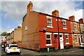
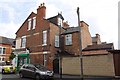
Glapton Road houses at Barnsley Terrace junction
There is an Ordnance Survey benchmark Image on the side of the house at the corner at the junction of the house and its side wall
Image: © Luke Shaw
Taken: 11 May 2019
0.05 miles
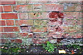
2
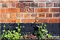
Benchmark on #34 Glapton Road (Barnsley Terrace face)
Ordnance Survey cut mark benchmark described on the Bench Mark Database at www.bench-marks.org.uk/bm112061
Image: © Luke Shaw
Taken: 11 May 2019
0.05 miles
3
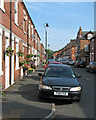
Flower baskets in Glapton Road
The majority of The Meadows district was cleared and redeveloped in the 1970s, but a number of terraced streets between the Embankment recreation ground and Wilford Crescent remain.
Image: © John Sutton
Taken: 23 Aug 2015
0.08 miles
4
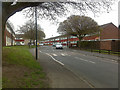
Wilford Crescent West
Typical of the 1960s development of the Meadows area of Nottingham. On the whole this has not been judged a success.
Image: © David Lally
Taken: 2 Apr 2009
0.09 miles
5
No. 93 Holgate Road, Glapton Road face
Ordnance Survey documents indicate that in 1962 a benchmark levelled at 25.573m above Newlyn Datum was verified on the roadside wall then present in the right hand half of the image, evidently replaced by a stone wall in recent times
Image: © Luke Shaw
Taken: 11 May 2019
0.09 miles
6
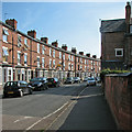
Wilford Crescent
Three-storey terraced houses typical of those built as Nottingham expanded rapidly in the last quarter of the 19th century.
Image: © John Sutton
Taken: 23 Aug 2015
0.12 miles
7

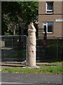
Queen's Walk: tram sign and story pole
Signs are going up now the tramway extension is nearing completion. The story pole recalls the industrial heritage of The Meadows, combining Nottingham lace and the headstocks of Clifton Colliery, which was once nearby. The houses in the background date from the redevelopment of The Meadows in the 1970s. They stand on the edge of what was once the Great Central Railway goods yards.
Image: © John Sutton
Taken: 26 Aug 2014
0.12 miles
8
Story Pole 8: Industry. Near Doyne Court
An alternative angle to my previous view http://www.geograph.org.uk/photo/4087769
and in better lighting conditions.
Image: © Alan Murray-Rust
Taken: 31 Aug 2014
0.12 miles
9
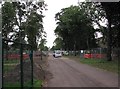
Queen's Walk: tramway construction site
The majority of the southern half of Queen's Walk is now fenced off. This picture was taken through gates opened to let the lorry out.
Image: © John Sutton
Taken: 12 Sep 2012
0.12 miles
10
Benchmark on No. 13 Wilford Crescent West
Ordnance Survey cut mark benchmark described on the Bench Mark Database at www.bench-marks.org.uk/bm112060
Image: © Luke Shaw
Taken: 11 May 2019
0.13 miles