IMAGES TAKEN NEAR TO
Petersmith Crescent, NEWARK, NG22 9SE
Introduction
This page details the photographs taken nearby to Petersmith Crescent, NG22 9SE by members of the Geograph project.
The Geograph project started in 2005 with the aim of publishing, organising and preserving representative images for every square kilometre of Great Britain, Ireland and the Isle of Man.

There are currently over 7.5m images from over14,400 individuals and you can help contribute to the project by visiting https://www.geograph.org.uk
Image Map
Images are licensed for reuse under creativecommons.org/licenses/by-sa/2.0
Notes
- Clicking on the map will re-center to the selected point.
- The higher the marker number, the further away the image location is from the centre of the postcode.
Image Listing (3 Images Found)
Images are licensed for reuse under creativecommons.org/licenses/by-sa/2.0
Image
Details
Distance
1
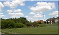
Benches on Hallam New Road
Looking at the frame in front of these benches this was some sort of commemorative event now defaced.
Image: © Steve Fareham
Taken: 4 Jul 2008
0.21 miles
2
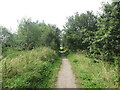
Bridleway along the River Maun
The river is not far to the left but hidden from view
Image: © John Slater
Taken: 21 Jul 2019
0.23 miles
3
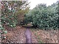
Robin Hood Way near Ollerton
The trail cuts across the north west corner of the grid square here.
Image: © Jonathan Clitheroe
Taken: 2 Aug 2022
0.24 miles