IMAGES TAKEN NEAR TO
Petersmith Drive, NEWARK, NG22 9RX
Introduction
This page details the photographs taken nearby to Petersmith Drive, NG22 9RX by members of the Geograph project.
The Geograph project started in 2005 with the aim of publishing, organising and preserving representative images for every square kilometre of Great Britain, Ireland and the Isle of Man.

There are currently over 7.5m images from over14,400 individuals and you can help contribute to the project by visiting https://www.geograph.org.uk
Image Map
Images are licensed for reuse under creativecommons.org/licenses/by-sa/2.0
Notes
- Clicking on the map will re-center to the selected point.
- The higher the marker number, the further away the image location is from the centre of the postcode.
Image Listing (7 Images Found)
Images are licensed for reuse under creativecommons.org/licenses/by-sa/2.0
Image
Details
Distance
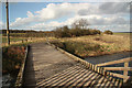
1
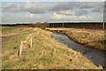
Whitewater Common
New bridleway beside the River Maun on Whitewater Common
Image: © Richard Croft
Taken: 12 Feb 2011
0.15 miles
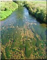
3
River Maun
River Maun and Whitewater Common from the bridge http://www.geograph.org.uk/photo/2270617
Image: © Richard Croft
Taken: 12 Feb 2011
0.16 miles
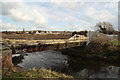
4
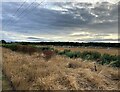
Piggery near Ollerton
Pictured from the Robin Hood Way next to the River Maun.
Image: © Jonathan Clitheroe
Taken: 2 Aug 2022
0.16 miles
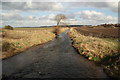
6
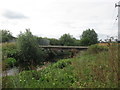
Maun Bridge
Bridleway bridge over the River Maun at New Ollerton
Image: © Richard Croft
Taken: 12 Feb 2011
0.20 miles
7
Maun Bridge
Bridleway bridge across the River Maun at New Ollerton
Image: © Richard Croft
Taken: 12 Feb 2011
0.21 miles