IMAGES TAKEN NEAR TO
Chapel Close, NEWARK, NG22 9NP
Introduction
This page details the photographs taken nearby to Chapel Close, NG22 9NP by members of the Geograph project.
The Geograph project started in 2005 with the aim of publishing, organising and preserving representative images for every square kilometre of Great Britain, Ireland and the Isle of Man.

There are currently over 7.5m images from over14,400 individuals and you can help contribute to the project by visiting https://www.geograph.org.uk
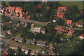
Image Map
Images are licensed for reuse under creativecommons.org/licenses/by-sa/2.0
Notes
- Clicking on the map will re-center to the selected point.
- The higher the marker number, the further away the image location is from the centre of the postcode.
Image Listing (45 Images Found)
Images are licensed for reuse under creativecommons.org/licenses/by-sa/2.0
Image
Details
Distance
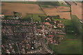
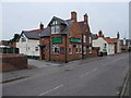
2
New Hill in Walesby
A typically prosaic image to bring up 5000 personal Geographs.
Image: © Jonathan Clitheroe
Taken: 2 Aug 2022
0.07 miles
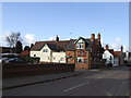
3
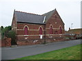
Methodist church, Chapel Street, Walesby
Date stone 1895. Looks to be disused.
Image: © Tim Heaton
Taken: 12 Apr 2009
0.08 miles
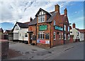
5

Disused Wesleyan Methodist Church, Walesby
All boarded up and ripe for residential conversion no doubt.
Image: © Mick Garratt
Taken: 7 Oct 2006
0.10 miles
8
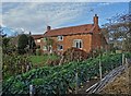
Traditional cottage in Walesby
With a fine row of brassicas in the foreground.
Image: © Neil Theasby
Taken: 13 Nov 2018
0.11 miles
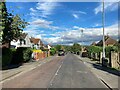
9
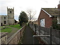
Footpath by the church
Links Tuxford Road to Manor Close.
Image: © Jonathan Thacker
Taken: 27 Nov 2015
0.16 miles