IMAGES TAKEN NEAR TO
Brake Lane, NEWARK, NG22 9NE
Introduction
This page details the photographs taken nearby to Brake Lane, NG22 9NE by members of the Geograph project.
The Geograph project started in 2005 with the aim of publishing, organising and preserving representative images for every square kilometre of Great Britain, Ireland and the Isle of Man.

There are currently over 7.5m images from over14,400 individuals and you can help contribute to the project by visiting https://www.geograph.org.uk
Image Map
Images are licensed for reuse under creativecommons.org/licenses/by-sa/2.0
Notes
- Clicking on the map will re-center to the selected point.
- The higher the marker number, the further away the image location is from the centre of the postcode.
Image Listing (7 Images Found)
Images are licensed for reuse under creativecommons.org/licenses/by-sa/2.0
Image
Details
Distance
1
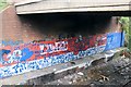
Bridge, Brake Lane
Over a disused mineral railway. A canvas for the local artists. Not quite the same league as Banksy.
Image: © Mick Garratt
Taken: 6 Oct 2007
0.14 miles
2
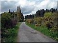
Brake Lane
Boughton Brake woodland on the right
Image: © norman griffin
Taken: 1 May 2006
0.20 miles
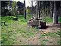
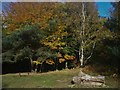
4
Boughton Brake
View towards Brake Lane car parking area
Image: © norman griffin
Taken: 20 Nov 2005
0.24 miles
5
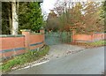
Boughton Pumping Station, north gate
Pumping station built 1905 for the Nottingham Corporation Water Works. The boundary wall and gates are Listed Grade II separately from the main buildings.
Image: © Alan Murray-Rust
Taken: 1 Dec 2019
0.24 miles
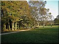
7
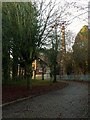
Boughton Pumping Station
This drive was originally the main access to the pumping station, and still provides access to the minor pump house, still in use for pumping water.
Image: © Alan Murray-Rust
Taken: 1 Dec 2019
0.25 miles