IMAGES TAKEN NEAR TO
Church Road, NEWARK, NG22 9JY
Introduction
This page details the photographs taken nearby to Church Road, NG22 9JY by members of the Geograph project.
The Geograph project started in 2005 with the aim of publishing, organising and preserving representative images for every square kilometre of Great Britain, Ireland and the Isle of Man.

There are currently over 7.5m images from over14,400 individuals and you can help contribute to the project by visiting https://www.geograph.org.uk
Image Map
Images are licensed for reuse under creativecommons.org/licenses/by-sa/2.0
Notes
- Clicking on the map will re-center to the selected point.
- The higher the marker number, the further away the image location is from the centre of the postcode.
Image Listing (27 Images Found)
Images are licensed for reuse under creativecommons.org/licenses/by-sa/2.0
Image
Details
Distance
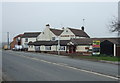
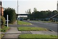
1
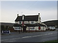
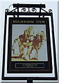
The Harrow Inn
The hill to the left is Wellow Park and that to the right is Ollerton Pits Wood on the site of the slag heap of Ollerton Colliery.
Image: © Jonathan Thacker
Taken: 18 Dec 2015
0.03 miles
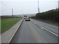
3
The Harrow Inn Boughton
Looking back to the railway bridge and the road to Ollerton.
Image: © Steve Fareham
Taken: 6 Nov 2007
0.04 miles
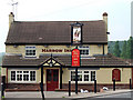
4
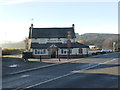
The Harrow Inn
Pub and restaurant in Boughton
Image: © Graham Hogg
Taken: 4 Dec 2018
0.04 miles
6
The Harrow Inn
Another public house in the Nottinghamshire area.
Image: © James Hill
Taken: 9 Jun 2007
0.06 miles
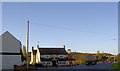
8
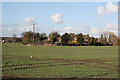
Boughton village
The one-time sleepy village of Boughton now sits rather uncomfortably close to neighbouring New Ollerton, this scene from Church Road illustrates this.
Image: © Richard Croft
Taken: 12 Feb 2011
0.09 miles
9
Boughton village
View from Cocking Hill to Boughton
Image: © Richard Croft
Taken: 12 Feb 2011
0.11 miles
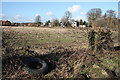
10
Railway Bridge, Tuxford Lane
Carrying a disused mineral railway serving Ollerton Pit.
Image: © Mick Garratt
Taken: 7 Oct 2007
0.12 miles