IMAGES TAKEN NEAR TO
Stepnall Heights, NEWARK, NG22 9HL
Introduction
This page details the photographs taken nearby to Stepnall Heights, NG22 9HL by members of the Geograph project.
The Geograph project started in 2005 with the aim of publishing, organising and preserving representative images for every square kilometre of Great Britain, Ireland and the Isle of Man.

There are currently over 7.5m images from over14,400 individuals and you can help contribute to the project by visiting https://www.geograph.org.uk
Image Map
Images are licensed for reuse under creativecommons.org/licenses/by-sa/2.0
Notes
- Clicking on the map will re-center to the selected point.
- The higher the marker number, the further away the image location is from the centre of the postcode.
Image Listing (3 Images Found)
Images are licensed for reuse under creativecommons.org/licenses/by-sa/2.0
Image
Details
Distance
1
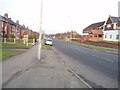
Main Road Boughton
As seen looking NE from junction with Tuxford Road
Image: © Geoff Dunn
Taken: 22 Jan 2006
0.18 miles
3
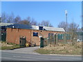
Telephone Exchange, New Ollerton
This TE is situated on the B6387 Retford Road, Boughton, NG22 9JN adjacent to a disused railway line. Its appearance is not enhanced by the green fencing and razor sharp wiring above it. The mobile phone mast can be seen on the right of the photo.
Image: © David Hillas
Taken: 8 Mar 2010
0.19 miles