IMAGES TAKEN NEAR TO
Perlethorpe, NEWARK, NG22 9EH
Introduction
This page details the photographs taken nearby to NG22 9EH by members of the Geograph project.
The Geograph project started in 2005 with the aim of publishing, organising and preserving representative images for every square kilometre of Great Britain, Ireland and the Isle of Man.

There are currently over 7.5m images from over14,400 individuals and you can help contribute to the project by visiting https://www.geograph.org.uk
Image Map
Images are licensed for reuse under creativecommons.org/licenses/by-sa/2.0
Notes
- Clicking on the map will re-center to the selected point.
- The higher the marker number, the further away the image location is from the centre of the postcode.
Image Listing (62 Images Found)
Images are licensed for reuse under creativecommons.org/licenses/by-sa/2.0
Image
Details
Distance
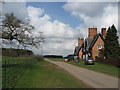
1
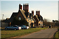
Meadow Cottages
Two pairs of grade II listed, attractive mid-19th century estate cottages at Perlethorpe
Image: © Richard Croft
Taken: 27 Dec 2011
0.00 miles
2
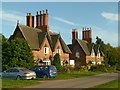
Meadow Cottages, Perlethorpe
Two pairs of mid 19th century cottages for the Thoresby Estate. Both are Listed Grade II.
Image: © Alan Murray-Rust
Taken: 11 Oct 2015
0.01 miles
3
Meadow Cottages
Long view to Meadow Cottages http://www.geograph.org.uk/photo/2743265 at Perlethorpe
Image: © Richard Croft
Taken: 27 Dec 2011
0.01 miles
4
Meadow Cottages
Estate cottages overlooking a meadow at Perlethorpe
Image: © Richard Croft
Taken: 11 Jun 2011
0.02 miles
5
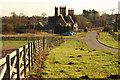
Thoresby Park Estate - Houses entering Perlethorpe
Image: © Alan Heardman
Taken: 27 Mar 2008
0.02 miles
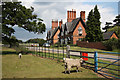
7
Lane and cottages in Perlethorpe
Among the many ancient oaks on this Thoresby estate is, inevitably, the occasional dead one!
Image: © Chris
Taken: 3 Jul 2016
0.05 miles
8
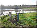
Flooded Meden Vale
View south-west across the shallow valley to Thoresby Home Farm buildings and the spire of St John's church. The signs indicate that the footpath following the river is closed and warn of the 'danger of deep water'. At least the swan out in the middle seemed happy with the situation.
Image: © Trevor Rickard
Taken: 11 Mar 2014
0.05 miles
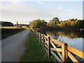
9
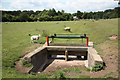
Sheep Dip
What appears to be a sluice gate and sheep dip at the end of a dry channel from the River Meden.
Image: © Richard Croft
Taken: 11 Jun 2011
0.05 miles
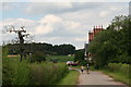
10
Thoresby estate
View west from The Kennels http://www.geograph.org.uk/photo/2743292 towards Century House http://www.geograph.org.uk/photo/2454861
Image: © Richard Croft
Taken: 4 Jun 2013
0.05 miles