IMAGES TAKEN NEAR TO
Tor Lane, NEWARK, NG22 9BT
Introduction
This page details the photographs taken nearby to Tor Lane, NG22 9BT by members of the Geograph project.
The Geograph project started in 2005 with the aim of publishing, organising and preserving representative images for every square kilometre of Great Britain, Ireland and the Isle of Man.

There are currently over 7.5m images from over14,400 individuals and you can help contribute to the project by visiting https://www.geograph.org.uk
Image Map
Images are licensed for reuse under creativecommons.org/licenses/by-sa/2.0
Notes
- Clicking on the map will re-center to the selected point.
- The higher the marker number, the further away the image location is from the centre of the postcode.
Image Listing (86 Images Found)
Images are licensed for reuse under creativecommons.org/licenses/by-sa/2.0
Image
Details
Distance
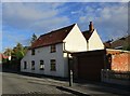
2

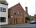
Ollerton old fire station
Ollerton old fire station, Station Road, Ollerton, Nottinghamshire
Image: © Kevin Hale
Taken: 5 Dec 2009
0.08 miles
3
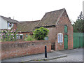
Bieldside, Station Road
Dwelling converted from what appears to have been a small stable block and hayloft.
Image: © Alan Murray-Rust
Taken: 8 Aug 2014
0.09 miles
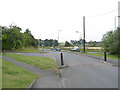
4
Ollerton - Station Road junction with A614
Image: © Alan Heardman
Taken: 17 Mar 2009
0.10 miles
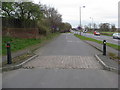
5
Station Road and A614
The latter was built in the 1930s to bypass the village. Plentiful ramps keep speeds of local traffic down on the old road.
Image: © Alan Murray-Rust
Taken: 8 Aug 2014
0.10 miles
6
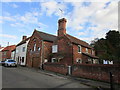
Former Ebenezer Primitive Methodist chapel, Station Road
Now converted to a house, complete with built-in garage. Dated to 1869 http://www.geograph.org.uk/photo/4113675
Image: © Alan Murray-Rust
Taken: 8 Aug 2014
0.10 miles
7
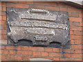
Datestone, Ebenezer Chapel
It's not clear what period the attempt to blot out the name dates from. It could be from when the Primitive Methodists ceased to be a separate group, or alternatively when the building http://www.geograph.org.uk/photo/4113671 ceased to be a chapel.
Image: © Alan Murray-Rust
Taken: 8 Aug 2014
0.11 miles
8
Station Road, Ollerton
The building in the centre of the picture is the former Primitive Methodist chapel dating from 1869.
Image: © Jonathan Thacker
Taken: 20 Oct 2018
0.11 miles
9
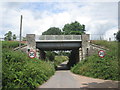
Railway bridge over Bescar Lane, Ollerton
Image: © John Slater
Taken: 21 Jul 2019
0.11 miles
10
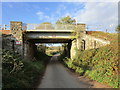
Bescar lane railway bridge
Carries the former Lancashire, Derbyshire and East Coast Railway line. This is now only used as a test track as far east as the former High Marnham power station site.
Image: © Jonathan Thacker
Taken: 20 Oct 2018
0.11 miles