IMAGES TAKEN NEAR TO
Forest Link, NEWARK, NG22 8UD
Introduction
This page details the photographs taken nearby to Forest Link, NG22 8UD by members of the Geograph project.
The Geograph project started in 2005 with the aim of publishing, organising and preserving representative images for every square kilometre of Great Britain, Ireland and the Isle of Man.

There are currently over 7.5m images from over14,400 individuals and you can help contribute to the project by visiting https://www.geograph.org.uk
Image Map
Images are licensed for reuse under creativecommons.org/licenses/by-sa/2.0
Notes
- Clicking on the map will re-center to the selected point.
- The higher the marker number, the further away the image location is from the centre of the postcode.
Image Listing (18 Images Found)
Images are licensed for reuse under creativecommons.org/licenses/by-sa/2.0
Image
Details
Distance
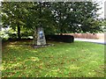
3
The start of the Southwell trail at Bilsthorpe
Image: © Steve Fareham
Taken: 29 Sep 2015
0.15 miles
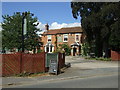
4
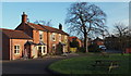
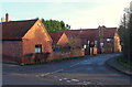
Kirklington Road, Bilsthorpe, Notts.
A view of this 'C' road from the car park of the village's only public house. The Copper Beech pub is named after the specimen towering over the gateway. The pub was a former farm house built c.1812 but it converted to a pub in 1985. An extension for a dining area - nearest to the photographer - was added later. The white van is travelling away from the village's centre.
Image: © David Hallam-Jones
Taken: 16 Jan 2015
0.16 miles
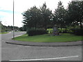
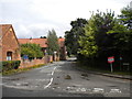
5
Road Junction and Rectory Barn in Bilsthorpe
Church Hill leading to The Church of St Margaret is to the right of picture.
Image: © Jonathan Clitheroe
Taken: 26 Aug 2022
0.16 miles
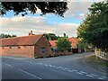
8
Bottom of Church Hill, Bilsthorpe
Seen from Kirklington Road.
Image: © Richard Vince
Taken: 2 Aug 2014
0.17 miles
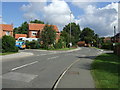
9
Church Hill, Bilsthorpe, Notts.
Church Hill, a cul-de-sac, is seen here joining/leaving Kirklington Road.
Image: © David Hallam-Jones
Taken: 16 Jan 2015
0.18 miles
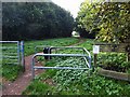
10
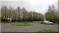
Southwell Trail at Bilsthorpe
Mining as a career has gone, but new employment opportunities have appeared. Dog walking is now a major source of income for many who are happy to enjoy fresh air and love animals - whatever the weather. Mud is normal.
19th Century railway lines are providing unimagined opportunities in the 21st Century!
Image: © Chris Morgan
Taken: 5 Jan 2016
0.19 miles