IMAGES TAKEN NEAR TO
Brailwood Road, NEWARK, NG22 8UA
Introduction
This page details the photographs taken nearby to Brailwood Road, NG22 8UA by members of the Geograph project.
The Geograph project started in 2005 with the aim of publishing, organising and preserving representative images for every square kilometre of Great Britain, Ireland and the Isle of Man.

There are currently over 7.5m images from over14,400 individuals and you can help contribute to the project by visiting https://www.geograph.org.uk
Image Map
Images are licensed for reuse under creativecommons.org/licenses/by-sa/2.0
Notes
- Clicking on the map will re-center to the selected point.
- The higher the marker number, the further away the image location is from the centre of the postcode.
Image Listing (9 Images Found)
Images are licensed for reuse under creativecommons.org/licenses/by-sa/2.0
Image
Details
Distance
1
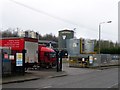
A more unusual combination?
Private ambulances, but if all help fails, that black sign denotes the undertaker is also here.
Image: © Chris Morgan
Taken: 5 Jan 2016
0.02 miles
3
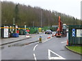
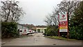
Bilsthorpe Recycling Centre
Just a short distance away from a commercial hazardous waste disposal facility Image
Image: © Graham Hogg
Taken: 5 Jan 2016
0.06 miles
4
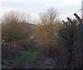
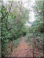
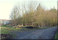
Brailwood Road Vicinity, Bilsthorpe, Notts.
A footpath that links Brailford Road (2 mins behind the photographer) with the south-western edge of Eakring Brail Wood (3-4 mins ahead). The high fence on the right aims to keep unauthorised individuals out of former colliery slag heaps, whilst the land on the left is the southern-most boundary of the former Bilsthorpe Colliery.
Image: © David Hallam-Jones
Taken: 16 Jan 2015
0.06 miles
5
Hazardous waste disposal facility
Just a short distance away from a council waste disposal/recycling site Image
Image: © Graham Hogg
Taken: 5 Jan 2016
0.14 miles
6
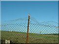
Bilsthorpe Tip Perimeter Fence
The fence draws the boundary between the picturesque country walk up to Brailwood and the odorous tip.
Image: © Dr Margaret Simms
Taken: 6 Nov 2007
0.17 miles
7
Kirklington Road Vicinity, Bilsthorpe, Notts.
The main track leads from Kirklington Road (behind the photographer) towards a covered reservoir ahead that is sandwiched between Eakring Brail Wood and Long Springs Wood. The footpath running in a north-easterly direction, parallel with the metal fencing, leads to Brail Wood Road (within 5 mins). The fence provides security for a vehicle-dismantling and scrap yard.
Image: © David Hallam-Jones
Taken: 16 Jan 2015
0.17 miles