IMAGES TAKEN NEAR TO
Kirklington Road, NEWARK, NG22 8TZ
Introduction
This page details the photographs taken nearby to Kirklington Road, NG22 8TZ by members of the Geograph project.
The Geograph project started in 2005 with the aim of publishing, organising and preserving representative images for every square kilometre of Great Britain, Ireland and the Isle of Man.

There are currently over 7.5m images from over14,400 individuals and you can help contribute to the project by visiting https://www.geograph.org.uk
Image Map
Images are licensed for reuse under creativecommons.org/licenses/by-sa/2.0
Notes
- Clicking on the map will re-center to the selected point.
- The higher the marker number, the further away the image location is from the centre of the postcode.
Image Listing (8 Images Found)
Images are licensed for reuse under creativecommons.org/licenses/by-sa/2.0
Image
Details
Distance
1
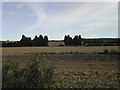
Willows Farm
between Kirklington and Bilsthorpe, it is on the edge of an Industrial Estate
Image: © Tom Courtney
Taken: 2 Oct 2005
0.03 miles
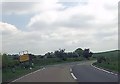
2
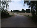
Road to Willow Farm, off Kirklington Road
Image: © J.Hannan-Briggs
Taken: 2 Oct 2011
0.05 miles
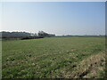
3
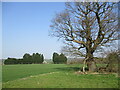
Fields near Willow Farm
Willow Farm largely hidden by trees.
Image: © Jonathan Thacker
Taken: 23 Mar 2022
0.06 miles
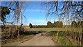
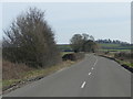
5
Beflle Eau Park industrial estate turning
From A617
Image: © John Firth
Taken: 9 Jun 2013
0.16 miles
8
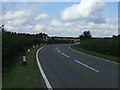
Bends in Kirklington Road (A617)
Towards Mansfield.
Image: © JThomas
Taken: 7 Sep 2013
0.23 miles