IMAGES TAKEN NEAR TO
Old Rufford Road, NEWARK, NG22 8TE
Introduction
This page details the photographs taken nearby to Old Rufford Road, NG22 8TE by members of the Geograph project.
The Geograph project started in 2005 with the aim of publishing, organising and preserving representative images for every square kilometre of Great Britain, Ireland and the Isle of Man.

There are currently over 7.5m images from over14,400 individuals and you can help contribute to the project by visiting https://www.geograph.org.uk
Image Map
Images are licensed for reuse under creativecommons.org/licenses/by-sa/2.0
Notes
- Clicking on the map will re-center to the selected point.
- The higher the marker number, the further away the image location is from the centre of the postcode.
Image Listing (4 Images Found)
Images are licensed for reuse under creativecommons.org/licenses/by-sa/2.0
Image
Details
Distance
3
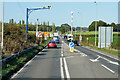
Traffic Cameras on the A614 at Primrose Hill
Image: © David Dixon
Taken: 13 Oct 2022
0.20 miles
4
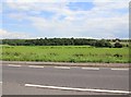
Fields east of A614
Looking east from the A614. The slightly broken hedgerow in the middle distance approximately marks the eastern edge of the grid square. The wood in the distance is Cutt's Wood in Image
Image: © David P Howard
Taken: 18 Jun 2012
0.22 miles