IMAGES TAKEN NEAR TO
Deerdale Lane, NEWARK, NG22 8SZ
Introduction
This page details the photographs taken nearby to Deerdale Lane, NG22 8SZ by members of the Geograph project.
The Geograph project started in 2005 with the aim of publishing, organising and preserving representative images for every square kilometre of Great Britain, Ireland and the Isle of Man.

There are currently over 7.5m images from over14,400 individuals and you can help contribute to the project by visiting https://www.geograph.org.uk
Image Map
Images are licensed for reuse under creativecommons.org/licenses/by-sa/2.0
Notes
- Clicking on the map will re-center to the selected point.
- The higher the marker number, the further away the image location is from the centre of the postcode.
Image Listing (7 Images Found)
Images are licensed for reuse under creativecommons.org/licenses/by-sa/2.0
Image
Details
Distance
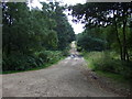
1
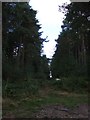
Track in woodland, Sherwood Pines Forest Park
Image: © JThomas
Taken: 7 Sep 2013
0.09 miles
2
Eakring Road heading west
Through Sherwood Forest.
Image: © JThomas
Taken: 7 Sep 2013
0.11 miles
3
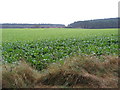
Sherwood Pines Forest Park
Cultivated land surrounded by trees.
Image: © Alan Heardman
Taken: 20 Oct 2009
0.15 miles
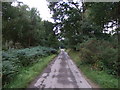
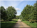
4
Sherwood Pines Forest Park
Adventure trail marker and access road.
Image: © Alan Heardman
Taken: 20 Oct 2009
0.18 miles
5
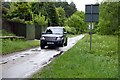
Geographer approaching
A timely arrival at the rendezvous for today's meanderings in Sherwood Forest
Image: © Graham Hogg
Taken: 2 Jun 2015
0.20 miles
6
Track in woodland, Sherwood Pines Forest Park
Image: © JThomas
Taken: 7 Sep 2013
0.24 miles
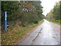
7
Track in Clipstone Forest
This part of the forest has many clearings and areas with scattered native trees such as oaks.
Image: © Jonathan Thacker
Taken: 6 Oct 2017
0.25 miles