IMAGES TAKEN NEAR TO
Eakring Road, NEWARK, NG22 8SX
Introduction
This page details the photographs taken nearby to Eakring Road, NG22 8SX by members of the Geograph project.
The Geograph project started in 2005 with the aim of publishing, organising and preserving representative images for every square kilometre of Great Britain, Ireland and the Isle of Man.

There are currently over 7.5m images from over14,400 individuals and you can help contribute to the project by visiting https://www.geograph.org.uk
Image Map
Images are licensed for reuse under creativecommons.org/licenses/by-sa/2.0
Notes
- Clicking on the map will re-center to the selected point.
- The higher the marker number, the further away the image location is from the centre of the postcode.
Image Listing (4 Images Found)
Images are licensed for reuse under creativecommons.org/licenses/by-sa/2.0
Image
Details
Distance
3
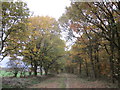
Path along the edge of Cutt's Wood
A considerable amount of undergrowth has recently been cleared from either side of the path.
Image: © Jonathan Thacker
Taken: 8 Nov 2018
0.21 miles
4
Electric Gate and Plastic Field
This modern day electrically operated 5 bar gate protects a farm entrance. The first 10 or so rows of plastic sheet are in this square with the majority of the field in the next one west.
Image: © Michael Patterson
Taken: 24 Mar 2006
0.23 miles