IMAGES TAKEN NEAR TO
Bilsthorpe Business Park, Eakring Road, NEWARK, NG22 8ST
Introduction
This page details the photographs taken nearby to Bilsthorpe Business Park, Eakring Road, NG22 8ST by members of the Geograph project.
The Geograph project started in 2005 with the aim of publishing, organising and preserving representative images for every square kilometre of Great Britain, Ireland and the Isle of Man.

There are currently over 7.5m images from over14,400 individuals and you can help contribute to the project by visiting https://www.geograph.org.uk
Image Map
Images are licensed for reuse under creativecommons.org/licenses/by-sa/2.0
Notes
- Clicking on the map will re-center to the selected point.
- The higher the marker number, the further away the image location is from the centre of the postcode.
Image Listing (6 Images Found)
Images are licensed for reuse under creativecommons.org/licenses/by-sa/2.0
Image
Details
Distance
1
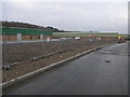
New Industry
Since the clearance of the former Bilsthorpe Colliery a new industrial estate has begun to be developed on the site.
Image: © Michael Patterson
Taken: 24 Mar 2006
0.03 miles
2
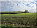
Spoilheap, former Bilsthorpe Colliery
Image: © Jonathan Thacker
Taken: 20 Oct 2018
0.18 miles
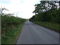
6
Wind turbine and spoil heap of former Bilsthorpe Colliery
Image: © Jonathan Thacker
Taken: 20 Oct 2018
0.22 miles