IMAGES TAKEN NEAR TO
Cheyne Drive, NEWARK, NG22 8SB
Introduction
This page details the photographs taken nearby to Cheyne Drive, NG22 8SB by members of the Geograph project.
The Geograph project started in 2005 with the aim of publishing, organising and preserving representative images for every square kilometre of Great Britain, Ireland and the Isle of Man.

There are currently over 7.5m images from over14,400 individuals and you can help contribute to the project by visiting https://www.geograph.org.uk
Image Map
Images are licensed for reuse under creativecommons.org/licenses/by-sa/2.0
Notes
- Clicking on the map will re-center to the selected point.
- The higher the marker number, the further away the image location is from the centre of the postcode.
Image Listing (20 Images Found)
Images are licensed for reuse under creativecommons.org/licenses/by-sa/2.0
Image
Details
Distance
1

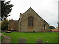
St Margaret's Church, Bilsthorpe, Notts.
The south side of this Grade I-listed Parish Church. It has a history of developments in the C13th, C14th, C15th and C16th with major restoration work in 1663 and then finally in 1873 by T. C. Hine of Nottingham.
Image: © David Hallam-Jones
Taken: 16 Jan 2015
0.14 miles
2

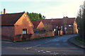
Church Hill, Bilsthorpe, Notts.
A view of the summit of Church Hill, a cul-de-sac, from the steps of St Margaret's Church. A path within the Church's 'overspill' cemetery is visible in the background.
Image: © David Hallam-Jones
Taken: 16 Jan 2015
0.14 miles
3

St Margaret's Church, Bilsthorpe, Notts.
Steps leading up to the church. St Margaret's Church is situated at the summit of Church Hill. The Rev. William Mompesson (of Eyam, the plague village) was the rector of both Wellow + Bilsthorpe & Eakring in the mid-1600s. The practice of “a living” being held in plurality, usually within that of the more populous parish, was apparently a common occurrence until this time. Later on in the same decade, Mompesson made his ill-fated move with his young family to Eyam, Derbyshire. From 1671 Mompesson held the parishes of Bilsthorpe and Eakring in plurality whilst residing most of the time at Eakring. He resigned the Bilsthorpe rectory in 1688 and at the end of July in that year Rev John Raworth was instituted as his successor. Raworth had been curate here for five years and less than a year after becoming rector, he married Elizabeth Mompesson, who had been sent away from Eyam as a 3 year old to escape the 1666 plague. At the time of her dispatch, the Rev. John Raworth was the ten year old son of the Eyam schoolmaster.
Image: © David Hallam-Jones
Taken: 16 Jan 2015
0.14 miles
5
Church Hill, Bilsthorpe, Notts.
Church Hill, a cul-de-sac, is seen here joining/leaving Kirklington Road.
Image: © David Hallam-Jones
Taken: 16 Jan 2015
0.15 miles
6
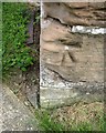
Ordnance Survey Cut Mark
This OS cut mark can be found on the SW angle of St Margaret's Church. It marks a point 82.357m above mean sea level.
Image: © Adrian Dust
Taken: 28 May 2016
0.15 miles
7
St. Margaret's church, Bilsthorpe, east end
Largely fourteenth century though the window is a sixteenth century insertion.
Image: © Jonathan Thacker
Taken: 5 Oct 2020
0.15 miles
8

St Margaret's Church, Bilsthorpe, Notts.
The east-facing end of this Grade I-listed Parish Church with the different colours and sizes of stones providing evidence of extensions and developments.
Image: © David Hallam-Jones
Taken: 16 Jan 2015
0.15 miles
9
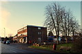
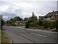
Kirklington Road, Bilsthorpe Moor, Notts.
A corner of a recreation ground at the junction with Maid Marian Avenue and a couple of 'local' shops. Farnsfield Road - ahead - can be reached within a few minutes on foot.
Image: © David Hallam-Jones
Taken: 16 Jan 2015
0.16 miles
10
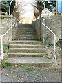
St. Margaret Church Steps
The steps, trodden by thousands of people over the centuries, are at the top of the quite steep Church Hill. Possibly the highest point in Bilsthorpe?
Image: © Dr Margaret Simms
Taken: 6 Nov 2007
0.16 miles