IMAGES TAKEN NEAR TO
Caunton Road, NEWARK, NG22 8PL
Introduction
This page details the photographs taken nearby to Caunton Road, NG22 8PL by members of the Geograph project.
The Geograph project started in 2005 with the aim of publishing, organising and preserving representative images for every square kilometre of Great Britain, Ireland and the Isle of Man.

There are currently over 7.5m images from over14,400 individuals and you can help contribute to the project by visiting https://www.geograph.org.uk
Image Map
Images are licensed for reuse under creativecommons.org/licenses/by-sa/2.0
Notes
- Clicking on the map will re-center to the selected point.
- The higher the marker number, the further away the image location is from the centre of the postcode.
Image Listing (7 Images Found)
Images are licensed for reuse under creativecommons.org/licenses/by-sa/2.0
Image
Details
Distance
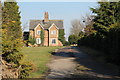
2
North Lodge Farm
near Winkburn, this farm used to be called Moor Farm
Image: © Tom Courtney
Taken: 6 Oct 2005
0.03 miles

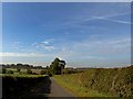
5
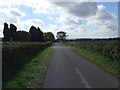
Country road heading south
Towards Winkburn.
Image: © JThomas
Taken: 7 Sep 2013
0.08 miles
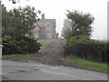
7
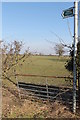
Footpath Entrance off Winkburn Lane
Image: © J.Hannan-Briggs
Taken: 17 Feb 2013
0.25 miles