IMAGES TAKEN NEAR TO
The Green, NEWARK, NG22 8NE
Introduction
This page details the photographs taken nearby to The Green, NG22 8NE by members of the Geograph project.
The Geograph project started in 2005 with the aim of publishing, organising and preserving representative images for every square kilometre of Great Britain, Ireland and the Isle of Man.

There are currently over 7.5m images from over14,400 individuals and you can help contribute to the project by visiting https://www.geograph.org.uk
Image Map
Images are licensed for reuse under creativecommons.org/licenses/by-sa/2.0
Notes
- Clicking on the map will re-center to the selected point.
- The higher the marker number, the further away the image location is from the centre of the postcode.
Image Listing (55 Images Found)
Images are licensed for reuse under creativecommons.org/licenses/by-sa/2.0
Image
Details
Distance
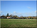
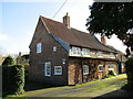
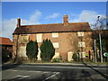
2
Highfield Farmhouse, Kirklington
Early eighteenth century farmhouse typical of smaller farmhouses of this period in this area https://historicengland.org.uk/listing/the-list/list-entry/1045493?section=official-list-entry
Image: © Jonathan Thacker
Taken: 21 Feb 2022
0.06 miles
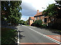
3
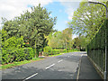
Southwell Road - 2
View north with the public footpath indicator on the bend ahead. Leafy lane with smart new housing behind neatly trimmed hedges.
Image: © Trevor Rickard
Taken: 1 May 2010
0.06 miles
4
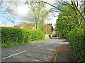
Southwell Road - 1
Looking north-east to the end of the road and the junction with the A617 Kirklington Road.
Image: © Trevor Rickard
Taken: 1 May 2010
0.09 miles
5
Linthwaite Cottage
Eighteenth century cottage https://historicengland.org.uk/listing/the-list/list-entry/1370187?section=official-list-entry
Image: © Jonathan Thacker
Taken: 21 Feb 2022
0.09 miles
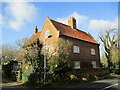
6
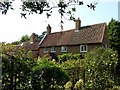
Linthwaite Cottage, Kirklington
Early 18th century with late 18th century extensions, Listed Grade II.
Image: © Alan Murray-Rust
Taken: 13 Sep 2020
0.09 miles
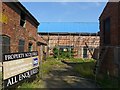
8
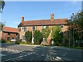
Ivy Farmhouse and Cottage, Kirklington
Late 18th century 3-bay house (between the chimney stacks), cottage to right added early 19th century with further, later additions to right, Listed Grade II.
Other photographic evidence indicates that the house has been unoccupied since at least 2004, and despite the 'property acquired' notice, there is no evidence of remedial work.
Image: © Alan Murray-Rust
Taken: 13 Sep 2020
0.11 miles
9
Ivy Farmhouse, Kirklington
Derelict eighteenth century farmhouse https://historicengland.org.uk/listing/the-list/list-entry/1285809?section=official-list-entry
Image: © Jonathan Thacker
Taken: 21 Feb 2022
0.11 miles
10
Farm buildings at Ivy Farm, Kirklington
The rear range temporarily roofed over, but the site appears to be devoid of any ongoing action.
Image: © Alan Murray-Rust
Taken: 13 Sep 2020
0.12 miles