IMAGES TAKEN NEAR TO
Alexander Road, NEWARK, NG22 8LH
Introduction
This page details the photographs taken nearby to Alexander Road, NG22 8LH by members of the Geograph project.
The Geograph project started in 2005 with the aim of publishing, organising and preserving representative images for every square kilometre of Great Britain, Ireland and the Isle of Man.

There are currently over 7.5m images from over14,400 individuals and you can help contribute to the project by visiting https://www.geograph.org.uk
Image Map
Images are licensed for reuse under creativecommons.org/licenses/by-sa/2.0
Notes
- Clicking on the map will re-center to the selected point.
- The higher the marker number, the further away the image location is from the centre of the postcode.
Image Listing (73 Images Found)
Images are licensed for reuse under creativecommons.org/licenses/by-sa/2.0
Image
Details
Distance
1
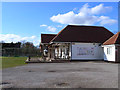
Off Station Lane, Farnsfield, Notts.
The entrance to Farnsfield Cricket Club, Station Lane. This ground, its second home, was first used in 1862.
Image: © David Hallam-Jones
Taken: 13 Dec 2014
0.05 miles
3
Off Station Lane, Farnsfield, Notts.
This, the second home of Farnsfield Cricket Club, was first used in 1862.
Image: © David Hallam-Jones
Taken: 13 Dec 2014
0.08 miles
4
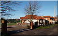
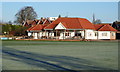
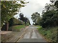
Alexander Road, Farnsfield
1950s housing development on the north side of the village.
Image: © Alan Murray-Rust
Taken: 20 Sep 2020
0.09 miles
5
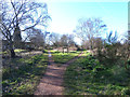
Farnsfield Junction
The Southwell Trail follows former railway lines. At Farnsfield there was a junction which the Southwell Trail reproduces. In the picture the lefthand fork follows the course of the Rolleston Junction - Mansfield line which here opened in 1871, closed to passengers in 1929 and to all traffic in 1965. The righthand fork follows the course of the former LMS/LNER Joint railway from Farnsfield Junction to Ollerton. The line opened in 1931 and this section closed in 1963. It was purely a mineral railway serving two collieries and never carried passenger traffic.
Image: © Jonathan Thacker
Taken: 30 Jul 2010
0.11 miles
6
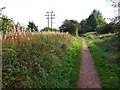
Power lines alongside the Southwell Trail
Image: © Steve Fareham
Taken: 29 Sep 2015
0.12 miles
7
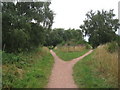
Junction of railway paths
Near the site of the old Farnsfield Station on the Mansfield, Southwell and Rolleston Junction Railway, built in 1847, closed to passengers in 1959 and wholly in 1964. Behind and straight ahead, the trackbed has been converted into a trail for walkers, cyclists and horseriders known as the Southwell Trail, which runs through from Southwell. To the right is a branch which ran to Ollerton (opened 1931) which has also been converted into a trail.
Image: © Oliver Dixon
Taken: 7 Mar 2014
0.12 miles
8
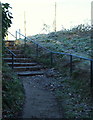
Off Mansfield Road, Farnsfield, Notts.
A flight of steps linking Mansfield Road (behind the photographer) and the local cricket ground (off Station Lane). The local village lock-up is situated half a dozen steps away, on the east side of Mansfield Road.
Image: © David Hallam-Jones
Taken: 13 Dec 2014
0.13 miles
9
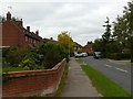
Broomfield Lane in Farnsfield
Looking towards the village centre from a spot close to the Southwell Trail.
Image: © Jonathan Clitheroe
Taken: 9 Oct 2020
0.13 miles
10
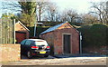
Mansfield Road, Farnsfield, Notts.
This Grade II-listed village lock-up on the east side of Mansfield Road was completed on 1 August 1850. Lock-ups originated during the C18th when rural communities struggled to deal with thefts, burglaries, shootings, drunkenness, the obstruction of watchmen and the theft of livestock. They were intended to be temporary places of detention until rogues and miscreants could be removed to a town. This one is occasionally open to the public on annual "Scarecrow Days" held in the village. Temporary holding facilities like this became redundant after the 1893 County Police Act made police stations with secure cells compulsory. A public footpath on the right climbs up a slope to the local cricket ground.
Image: © David Hallam-Jones
Taken: 13 Dec 2014
0.13 miles