IMAGES TAKEN NEAR TO
Longland Lane, NEWARK, NG22 8HW
Introduction
This page details the photographs taken nearby to Longland Lane, NG22 8HW by members of the Geograph project.
The Geograph project started in 2005 with the aim of publishing, organising and preserving representative images for every square kilometre of Great Britain, Ireland and the Isle of Man.

There are currently over 7.5m images from over14,400 individuals and you can help contribute to the project by visiting https://www.geograph.org.uk
Image Map
Images are licensed for reuse under creativecommons.org/licenses/by-sa/2.0
Notes
- Clicking on the map will re-center to the selected point.
- The higher the marker number, the further away the image location is from the centre of the postcode.
Image Listing (3 Images Found)
Images are licensed for reuse under creativecommons.org/licenses/by-sa/2.0
Image
Details
Distance
1
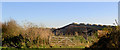
Longlands Farm
Gate and what looks like an extensive collection of poultry sheds behind.
Image: © Steve Fareham
Taken: 15 Nov 2007
0.07 miles
2
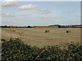
Stacking the Bales of straw
Longland Lane, near Farnsfield Village
Image: © Tom Courtney
Taken: 23 Aug 2005
0.16 miles