IMAGES TAKEN NEAR TO
Mansfield Road, NEWARK, NG22 8HF
Introduction
This page details the photographs taken nearby to Mansfield Road, NG22 8HF by members of the Geograph project.
The Geograph project started in 2005 with the aim of publishing, organising and preserving representative images for every square kilometre of Great Britain, Ireland and the Isle of Man.

There are currently over 7.5m images from over14,400 individuals and you can help contribute to the project by visiting https://www.geograph.org.uk
Image Map
Images are licensed for reuse under creativecommons.org/licenses/by-sa/2.0
Notes
- Clicking on the map will re-center to the selected point.
- The higher the marker number, the further away the image location is from the centre of the postcode.
Image Listing (112 Images Found)
Images are licensed for reuse under creativecommons.org/licenses/by-sa/2.0
Image
Details
Distance
1
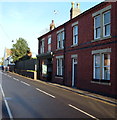
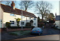
Main Road, Farnsfield, Notts.
"The Lion" public house/restaurant (previously "The Red Lion") is behind the photographer on the right-hand side. This is a view of Main Street before it becomes Mansfield Road with some terraced houses and a former shop. By continuing straight ahead the junction with the Old Rufford Road (i.e. the A614) can be reached in approximately 5 minutes (i.e. by car).
Image: © David Hallam-Jones
Taken: 6 Dec 2014
0.02 miles
2
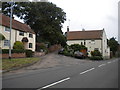
Bottom of Chapel Lane, Farnsfield
Seen from Mansfield Road.
Image: © Richard Vince
Taken: 2 Aug 2014
0.02 miles
4
The Lion at Farnsfield
Pub and restaurant in the centre of the village
Image: © Graham Hogg
Taken: 22 Feb 2016
0.03 miles
5
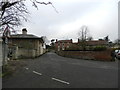
Chapel Lane, Farnsfield, Notts.
The south-western end of Chapel Lane (formerly Back Lane) from Mansfield Road. The Methodist Church can be found at the top of this rise, on the other side of New Hill.
Image: © David Hallam-Jones
Taken: 6 Dec 2014
0.04 miles
6
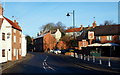
Main Road, Farnsfield, Notts.
With "The Lion" public house/restaurant (previously known as "The Red Lion") on the right this is a view of Main Street before it becomes Mansfield Road. This leads to the junction with the Old Rufford Road (i.e. the A614) in approximately 5 minutes (by car).
Image: © David Hallam-Jones
Taken: 6 Dec 2014
0.04 miles
7
Centre of Farnsfield
The Lion is at the heart of it.
Image: © Chris Morgan
Taken: 22 Feb 2016
0.04 miles
8
Mansfield Road, Farnsfield, Notts.
By no means 'a one horse town', this village still boasts many facilities that others would love to have including shops, a library and a thriving Village Community Centre. Finger posts next to the bus stop flag up the existence of a couple of footpaths across this frosty field.
Image: © David Hallam-Jones
Taken: 6 Dec 2014
0.04 miles
9
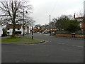
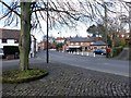
Road junction, Main Street and Mansfield Road
Image: © Peter Barr
Taken: 28 Feb 2012
0.04 miles
10
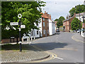
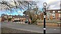
The bottom of Mansfield Road
The fingerpost is a Notts C C traditional cast-iron type with annulus finial.
Image: © Alan Murray-Rust
Taken: 1 Jun 2014
0.05 miles