IMAGES TAKEN NEAR TO
Colliery Way, NG22 8GG
Introduction
This page details the photographs taken nearby to Colliery Way, NG22 8GG by members of the Geograph project.
The Geograph project started in 2005 with the aim of publishing, organising and preserving representative images for every square kilometre of Great Britain, Ireland and the Isle of Man.

There are currently over 7.5m images from over14,400 individuals and you can help contribute to the project by visiting https://www.geograph.org.uk
Image Map
Images are licensed for reuse under creativecommons.org/licenses/by-sa/2.0
Notes
- Clicking on the map will re-center to the selected point.
- The higher the marker number, the further away the image location is from the centre of the postcode.
Image Listing (27 Images Found)
Images are licensed for reuse under creativecommons.org/licenses/by-sa/2.0
Image
Details
Distance
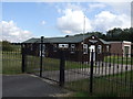
2
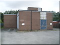
Bilsthorpe Telephone Exchange, Notts
Situated in Eakring Road, this building, of standard design, replaced the adjacent TE sometime during the early 1970s http://www.geograph.org.uk/photo/4105401 refers. Besides Bilsthorpe, this TE also serves Bilsthorpe Moor and Eakring nearby. Two square BT warning notices can be seen on the front of this TE. The numbering range of this TE is (01623) 87xxxx, the (01623) referring to the Mansfield group of TEs, and its postcode is NG22 8PY.
Image: © David Hillas
Taken: 2 Sep 2013
0.08 miles
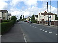
6
Former Telephone Exchange, Bilsthorpe
Situated in Eakring Road, this former TE was replaced by the building to the left of the photo sometime during the early 1970s http://www.geograph.org.uk/photo/4105431 refers. It is now occupied by a firm specialising in wheel repairs. The black roadsign in front of the new TE indicates an advisory route for lorries wishing to join the A614 road nearby.
Image: © David Hillas
Taken: 2 Sep 2013
0.09 miles
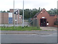
8
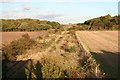
Rails under the grass and brambles
This was once the site of the rapid loading point for Bilsthorpe mine. The railway remains buried under the undergrowth . It would be good if someone could provide a picture taken here when the mine was working to compare the now empty view.
Image: © roger geach
Taken: 22 Sep 2009
0.11 miles
9
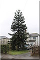
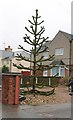
Monkey Puzzle Tree, Eakring Road, Bilsthorpe
Image: © J.Hannan-Briggs
Taken: 10 Feb 2013
0.11 miles