IMAGES TAKEN NEAR TO
Holme Lane, NEWARK, NG22 8FU
Introduction
This page details the photographs taken nearby to Holme Lane, NG22 8FU by members of the Geograph project.
The Geograph project started in 2005 with the aim of publishing, organising and preserving representative images for every square kilometre of Great Britain, Ireland and the Isle of Man.

There are currently over 7.5m images from over14,400 individuals and you can help contribute to the project by visiting https://www.geograph.org.uk
Image Map
Images are licensed for reuse under creativecommons.org/licenses/by-sa/2.0
Notes
- Clicking on the map will re-center to the selected point.
- The higher the marker number, the further away the image location is from the centre of the postcode.
Image Listing (10 Images Found)
Images are licensed for reuse under creativecommons.org/licenses/by-sa/2.0
Image
Details
Distance
1
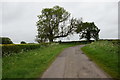
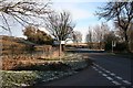
Junction Station Rd and Holme Lane
near Edingly Village
Image: © Tom Courtney
Taken: 23 Aug 2005
0.02 miles
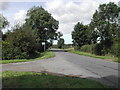
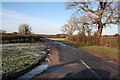
3
Kirklington turn left
The road left led to the station and Kirklington village.
Image: © roger geach
Taken: 17 Dec 2010
0.06 miles
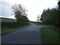
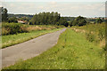
4
Cold morning on the road
Rural route to Kirklington.
Image: © roger geach
Taken: 17 Dec 2010
0.09 miles
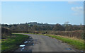
6
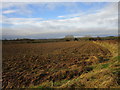
Ploughed field
Harlow Fields in the distance.
A brief spell of sunshine on a generally dull day.
Image: © Jonathan Thacker
Taken: 5 Jan 2020
0.13 miles
7
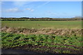
Land off Holme Lane
A rare sunny day at the end of January.
Image: © Julian P Guffogg
Taken: 30 Jan 2016
0.21 miles
8
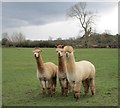
"Sisters, sisters"
Or are they? Alpacas near Highfields.
Image: © Jonathan Thacker
Taken: 9 Apr 2016
0.23 miles