IMAGES TAKEN NEAR TO
Allesford Lane, NEWARK, NG22 8FR
Introduction
This page details the photographs taken nearby to Allesford Lane, NG22 8FR by members of the Geograph project.
The Geograph project started in 2005 with the aim of publishing, organising and preserving representative images for every square kilometre of Great Britain, Ireland and the Isle of Man.

There are currently over 7.5m images from over14,400 individuals and you can help contribute to the project by visiting https://www.geograph.org.uk
Image Map
Images are licensed for reuse under creativecommons.org/licenses/by-sa/2.0
Notes
- Clicking on the map will re-center to the selected point.
- The higher the marker number, the further away the image location is from the centre of the postcode.
Image Listing (64 Images Found)
Images are licensed for reuse under creativecommons.org/licenses/by-sa/2.0
Image
Details
Distance
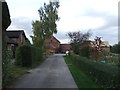
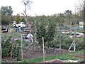
3
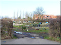
Allotments at Edingley
With a large modern house (not shown on map) beyond.
Image: © Oliver Dixon
Taken: 7 Mar 2014
0.11 miles
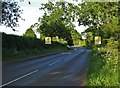
5
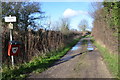
Public Footpath, Edingley
The path goes to the Southwell Trail
Image: © Julian P Guffogg
Taken: 30 Jan 2016
0.13 miles
7
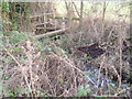
Footbridge over a branch of Edingley Beck
This carries the Edingley to Farnsfield footpath
Image: © Jim Thornton
Taken: 5 Jan 2008
0.16 miles
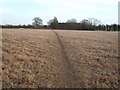
9
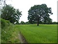
Solitary tree in a grass field
Beside a footpath linking Farnsfield and Edingley
Image: © Graham Hogg
Taken: 21 Jun 2016
0.17 miles
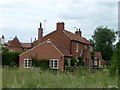
10
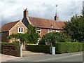
Norwood Park Farmhouse, Edingley
Mid 18th century farmhouse, Listed Grade II.
Image: © Alan Murray-Rust
Taken: 6 Sep 2020
0.17 miles