IMAGES TAKEN NEAR TO
Blidworth Road, NEWARK, NG22 8EZ
Introduction
This page details the photographs taken nearby to Blidworth Road, NG22 8EZ by members of the Geograph project.
The Geograph project started in 2005 with the aim of publishing, organising and preserving representative images for every square kilometre of Great Britain, Ireland and the Isle of Man.

There are currently over 7.5m images from over14,400 individuals and you can help contribute to the project by visiting https://www.geograph.org.uk
Image Map
Images are licensed for reuse under creativecommons.org/licenses/by-sa/2.0
Notes
- Clicking on the map will re-center to the selected point.
- The higher the marker number, the further away the image location is from the centre of the postcode.
Image Listing (121 Images Found)
Images are licensed for reuse under creativecommons.org/licenses/by-sa/2.0
Image
Details
Distance
1
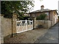
Gate and lodge to Farnsfield Hall
Early 18th century, lodge and gates together are Listed Grade II.
Image: © Alan Murray-Rust
Taken: 20 Sep 2020
0.00 miles
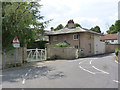
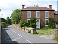
2
The Lodge, Farnsfield
Dates from the early nineteenth century https://historicengland.org.uk/listing/the-list/list-entry/1045506?section=official-list-entry
Image: © Jonathan Thacker
Taken: 23 Sep 2023
0.01 miles
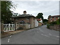
3
Farnsfield Hall Lodge
Early 19th century lodge house, with a distinctive wide eaves profile. Listed Grade II, including the gateway and boundary wall.
Image: © Alan Murray-Rust
Taken: 1 Jun 2014
0.01 miles
5
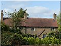
Holdyke Cottage, Farnsfield
Late 18th century, originally 2 cottages, now combined. Listed Grade II.
Image: © Alan Murray-Rust
Taken: 20 Sep 2020
0.02 miles
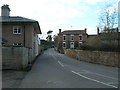
6
Thornbeck, Blidworth Road
An attractive Victorian house.
Image: © Alan Murray-Rust
Taken: 1 Jun 2014
0.02 miles
7
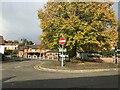
Farnsfield Village Centre
The Lion Inn can also be seen here towards the left of picture. The apparent contrast in socio-economic status between this village and Blidworth - just 3 miles down the road is sobering.
Image: © Jonathan Clitheroe
Taken: 9 Oct 2020
0.02 miles
8
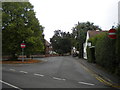
Main Street, Farnsfield, Notts.
Buses on certain routes serving the village use these roads as a turning circle prior to returning to the White Gate Farm junction of the A61 and proceeding to either Nottingham or Ollerton. The central signpost however, also flags up the road to Blidworth that passes in front of the red-painted gates.
Image: © David Hallam-Jones
Taken: 6 Dec 2014
0.03 miles
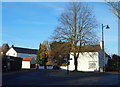
9
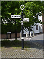
Fingerpost, Main Street/Blidworth Road
Notts C C traditional cast-iron with annulus finial.
Image: © Alan Murray-Rust
Taken: 1 Jun 2014
0.03 miles
10
Bus turning circle, Farnsfield (1)
Off Main Street opposite the Lion pub. Buses on the 28 from Newark to Mansfield call in here, and the Sherwood Arrow turns here in order to serve Farnsfield on its way between Nottingham and New Ollerton, but for some reason the 28B between Mansfield and Eakring does not do the same, thereby omitting the village proper.
Image: © Richard Vince
Taken: 2 Aug 2014
0.03 miles