IMAGES TAKEN NEAR TO
Quaker Lane, NEWARK, NG22 8EE
Introduction
This page details the photographs taken nearby to Quaker Lane, NG22 8EE by members of the Geograph project.
The Geograph project started in 2005 with the aim of publishing, organising and preserving representative images for every square kilometre of Great Britain, Ireland and the Isle of Man.

There are currently over 7.5m images from over14,400 individuals and you can help contribute to the project by visiting https://www.geograph.org.uk
Image Map
Images are licensed for reuse under creativecommons.org/licenses/by-sa/2.0
Notes
- Clicking on the map will re-center to the selected point.
- The higher the marker number, the further away the image location is from the centre of the postcode.
Image Listing (120 Images Found)
Images are licensed for reuse under creativecommons.org/licenses/by-sa/2.0
Image
Details
Distance
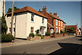
1
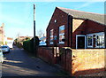
Quaker Lane, Farnsfield, Notts.
Although this has been a private residence for a number of years now (since ?), this hall - known as Quaker Lane Hall - was previously used as the meeting place of the local Women's Institute. However, before that - as suggested by its name - it was a Quaker Meeting House. At one time it seems that Quakers in Farnsfield were well represented as a religious group, with many more Quaker residents for its size than a good many larger villages and towns in Nottinghamshire. Ahead the road empties out into Main Street.
Image: © David Hallam-Jones
Taken: 6 Dec 2014
0.03 miles
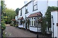
2
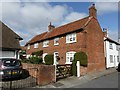
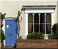
Jasmine Cottage, Quaker Lane, Farnsfield
Mid 18th century, possibly originally more than one dwelling, and with the far bay probably of later date. Listed Grade II.
Image: © Alan Murray-Rust
Taken: 20 Sep 2020
0.06 miles
3
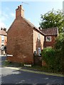
2 Quaker Lane, Farnsfield
Late 18th century cottage with 20th century projecting wing, Listed Grade II.
Image: © Alan Murray-Rust
Taken: 20 Sep 2020
0.08 miles
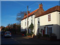
4
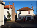
Quaker Lane/Main Street Junction, Farnsfield, Notts.
As suggested by its name this road was previously housed a Society of Friends (Quaker) Meeting House. The former meeting house still exists 50 metres or so behind the photographer and is called Quaker Lane Hall. After a period of use as the regular meeting place of the local Women's Institute it was converted into a private residence. Previously it seems that Quakers in Farnsfield were well represented as a religious group, with many more Quaker residents for its size than a good many larger villages and towns in Nottinghamshire. Ahead is Main Street.
Image: © David Hallam-Jones
Taken: 6 Dec 2014
0.08 miles
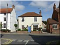
6
Main Street, Farnsfield, Notts.
The former Wheatsheaf public house and Drayman's Cottage obliquely opposite Quaker Lane. These are Grade II-listed mid-C18th buildings that are now residential units. The nearby former Maltings (now "The Village Centre") date from the early C19th.
Image: © David Hallam-Jones
Taken: 6 Dec 2014
0.09 miles
8
Wheatsheaf Cottage, Main Street, Farnsfield
Late 18th century house with an attractive 19th century shop window, Listed Grade II.
Image: © Alan Murray-Rust
Taken: 20 Sep 2020
0.09 miles
9
Wheatsheaf Cottage, Main Street, Farnsfield ? detail
Showing the attractive 19th century shop window, see http://www.geograph.org.uk/photo/6611478 for location.
Image: © Alan Murray-Rust
Taken: 20 Sep 2020
0.09 miles
10
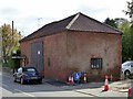
Barn at Old Manor Farm, Farnsfield
Early 19th century, relatively unusual in having a hipped rather than gabled roof, Listed Grade II.
Image: © Alan Murray-Rust
Taken: 20 Sep 2020
0.09 miles