IMAGES TAKEN NEAR TO
D'Ayncourt Walk, NEWARK, NG22 8DP
Introduction
This page details the photographs taken nearby to D'Ayncourt Walk, NG22 8DP by members of the Geograph project.
The Geograph project started in 2005 with the aim of publishing, organising and preserving representative images for every square kilometre of Great Britain, Ireland and the Isle of Man.

There are currently over 7.5m images from over14,400 individuals and you can help contribute to the project by visiting https://www.geograph.org.uk
Image Map
Images are licensed for reuse under creativecommons.org/licenses/by-sa/2.0
Notes
- Clicking on the map will re-center to the selected point.
- The higher the marker number, the further away the image location is from the centre of the postcode.
Image Listing (37 Images Found)
Images are licensed for reuse under creativecommons.org/licenses/by-sa/2.0
Image
Details
Distance
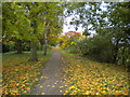
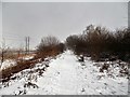
1
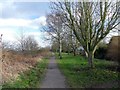
On the Southwell Trail
To the north of Farnsfield. The Southwell Trail is a leisure route on the former Southwell - Mansfield railway
Image: © Graham Hogg
Taken: 22 Feb 2016
0.03 miles
2
Southwell Trail at Farnsfield
The Mansfield, Southwell and Rolleston Junction Railway, built in 1847, closed to passengers in 1959 and wholly in 1964 has been converted into a trail for walkers, cyclists and horseriders known as the Southwell Trail, which runs through from Bilsthorpe to Southwell. The eastern end of the trail from Farnsfield to Southwell is in quite reasonable condition; the northern limb on to Bilsthorpe much less so.
Image: © Oliver Dixon
Taken: 7 Mar 2014
0.03 miles
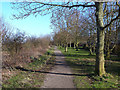
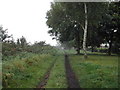
3
Footpath to the Ridgeway, Farnsfield
From the Southwell Trail.
Image: © Richard Vince
Taken: 24 Oct 2020
0.04 miles
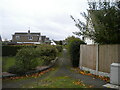
4
Dwellings Overlooking the Southwell Trail
Homes in Farnsfield which were almost certainly built after the railway line's demise in 1964. This picture is taken in the extreme south west corner of the grid square.
Image: © Jonathan Clitheroe
Taken: 9 Oct 2020
0.04 miles
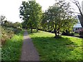
5
Southwell Trail, Farnsfield (2)
Skirting the northern edge of the village. This trail is mostly on the trackbed of the former Midland Railway line from Rolleston to Mansfield.
Image: © Richard Vince
Taken: 24 Oct 2020
0.04 miles
6
Southwell Trail
on the northern edge of Farnsfield on a misty October morning, viewed south east. It is a popular cycleway, footpath and bridleway
Image: © Tom Courtney
Taken: 6 Oct 2005
0.04 miles
7
Houses at Farnsfield alongside the Southwell Trail
Image: © Steve Fareham
Taken: 29 Sep 2015
0.04 miles
8
Southwell Trail, Farnsfield (1)
Skirting the northern edge of the village. This trail is mostly on the trackbed of the former Midland Railway line from Rolleston to Mansfield.
Image: © Richard Vince
Taken: 24 Oct 2020
0.05 miles
9
Southwell Trail
Not a day for sitting down in Farnsfield
Image: © norman griffin
Taken: 28 Feb 2018
0.07 miles
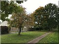
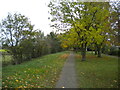
10
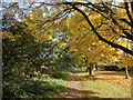
Southwell Trail in the Autumn
Tree in Autumn colours in Farnsfield.
Image: © norman griffin
Taken: 19 Oct 2015
0.08 miles