IMAGES TAKEN NEAR TO
Edingley, NEWARK, NG22 8DA
Introduction
This page details the photographs taken nearby to NG22 8DA by members of the Geograph project.
The Geograph project started in 2005 with the aim of publishing, organising and preserving representative images for every square kilometre of Great Britain, Ireland and the Isle of Man.

There are currently over 7.5m images from over14,400 individuals and you can help contribute to the project by visiting https://www.geograph.org.uk
Image Map
Images are licensed for reuse under creativecommons.org/licenses/by-sa/2.0
Notes
- Clicking on the map will re-center to the selected point.
- The higher the marker number, the further away the image location is from the centre of the postcode.
Image Listing (8 Images Found)
Images are licensed for reuse under creativecommons.org/licenses/by-sa/2.0
Image
Details
Distance
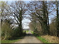
4
Footpath to Kirklington
Approaching the access road to Moor Farm.
Image: © Jonathan Thacker
Taken: 23 Mar 2022
0.13 miles
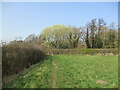
5
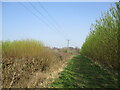
Footpath to Kirklington
Passes between two small plantations of willow grown for biomass.
Image: © Jonathan Thacker
Taken: 23 Mar 2022
0.15 miles
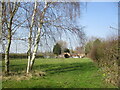
6
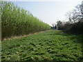
Grass strip alongside a biomass plantation
Image: © Jonathan Thacker
Taken: 23 Mar 2022
0.16 miles
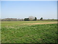
7
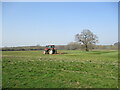
Farmer at work
Scarifying a grass field.
Image: © Jonathan Thacker
Taken: 23 Mar 2022
0.16 miles
8
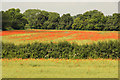
Poppies near Southwell Trail
Poppies in a field north of Southwell Trail near Kirklington
Image: © Richard Croft
Taken: 20 Jun 2014
0.21 miles