IMAGES TAKEN NEAR TO
Radley Road, NEWARK, NG22 8AT
Introduction
This page details the photographs taken nearby to Radley Road, NG22 8AT by members of the Geograph project.
The Geograph project started in 2005 with the aim of publishing, organising and preserving representative images for every square kilometre of Great Britain, Ireland and the Isle of Man.

There are currently over 7.5m images from over14,400 individuals and you can help contribute to the project by visiting https://www.geograph.org.uk
Image Map
Images are licensed for reuse under creativecommons.org/licenses/by-sa/2.0
Notes
- Clicking on the map will re-center to the selected point.
- The higher the marker number, the further away the image location is from the centre of the postcode.
Image Listing (3 Images Found)
Images are licensed for reuse under creativecommons.org/licenses/by-sa/2.0
Image
Details
Distance
2
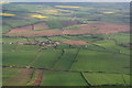
Area west of Southwell: aerial 2014
The power lines run from Oxton to Southwell.
Parts of a wind turbine in the centre, at New Holbeck Farm, and a field of ridge and furrow.
Image: © Chris
Taken: 9 Apr 2014
0.13 miles