IMAGES TAKEN NEAR TO
Fledborough, NEWARK, NG22 0UZ
Introduction
This page details the photographs taken nearby to NG22 0UZ by members of the Geograph project.
The Geograph project started in 2005 with the aim of publishing, organising and preserving representative images for every square kilometre of Great Britain, Ireland and the Isle of Man.

There are currently over 7.5m images from over14,400 individuals and you can help contribute to the project by visiting https://www.geograph.org.uk
Image Map
Images are licensed for reuse under creativecommons.org/licenses/by-sa/2.0
Notes
- Clicking on the map will re-center to the selected point.
- The higher the marker number, the further away the image location is from the centre of the postcode.
Image Listing (58 Images Found)
Images are licensed for reuse under creativecommons.org/licenses/by-sa/2.0
Image
Details
Distance
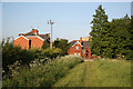
2
Station Cottages, Fledborough
Built by the Lancashire, Derbyshire and East Coast Railway in their standard style when the line was opened in 1896.
Image: © Alan Murray-Rust
Taken: 22 Aug 2014
0.01 miles
4
Route 647
Access ramp and bridge at the old Fledborough Station access point for NCN route 647
Image: © Richard Croft
Taken: 3 Jun 2010
0.01 miles
5
Crabtree Lane
Approaching the former Fledborough Station on Crabtree Lane, with Station Cottages http://www.geograph.org.uk/photo/1888988 on the left and the old Station House http://www.geograph.org.uk/photo/1895121 ahead
Image: © Richard Croft
Taken: 3 Jun 2010
0.02 miles
6
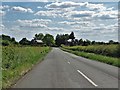
On Fledborough Road
Heading to Station Cottages. Fledborough Station was on the Chesterfield to Lincoln branch line. The station closed in 1955 though coal trains connected with High Marnham power station continued to run through right up until 1980.
Image: © Neil Theasby
Taken: 1 Jun 2020
0.02 miles
7
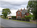
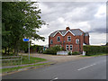
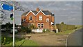
Station House, Fledborough
Built by the Lancashire, Derbyshire and East Coast Railway in their standard style when the line was opened in 1896.
Image: © Alan Murray-Rust
Taken: 22 Aug 2014
0.02 miles
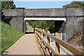
8
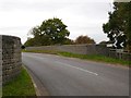
Fledborough Station, Bridge
This bridge crosses the former railway route at Fledborough station, now the west end of a cycle route along the former route from the vicinity of Lincoln. The far parapet carries a cut bench mark, see http://www.geograph.org.uk/photo/5181171 for a close-up.
Image: © Brian Westlake
Taken: 27 Oct 2016
0.03 miles
9
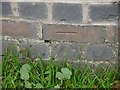
Cut Mark: Fledborough Station, Bridge
The cut mark on the north end of the west parapet. See http://www.geograph.org.uk/photo/5181168 and http://www.geograph.org.uk/photo/5181174 for further views. See http://www.bench-marks.org.uk/bm80102 for details of the mark.
Image: © Brian Westlake
Taken: 27 Oct 2016
0.03 miles
10
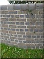
Cut Mark: Fledborough Station, Bridge
The cut mark on the north end of the west parapet. See http://www.geograph.org.uk/photo/5181171 for a close-up and http://www.geograph.org.uk/photo/5181174 for a wider view. See http://www.bench-marks.org.uk/bm80102 for details of the mark.
Image: © Brian Westlake
Taken: 27 Oct 2016
0.03 miles