IMAGES TAKEN NEAR TO
Fledborough, NEWARK, NG22 0UU
Introduction
This page details the photographs taken nearby to NG22 0UU by members of the Geograph project.
The Geograph project started in 2005 with the aim of publishing, organising and preserving representative images for every square kilometre of Great Britain, Ireland and the Isle of Man.

There are currently over 7.5m images from over14,400 individuals and you can help contribute to the project by visiting https://www.geograph.org.uk
Image Map
Images are licensed for reuse under creativecommons.org/licenses/by-sa/2.0
Notes
- Clicking on the map will re-center to the selected point.
- The higher the marker number, the further away the image location is from the centre of the postcode.
Image Listing (73 Images Found)
Images are licensed for reuse under creativecommons.org/licenses/by-sa/2.0
Image
Details
Distance
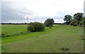
1

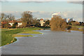
Oilseed rape near Fledborough
View from route 647 towards Fledborough
Image: © Richard Croft
Taken: 27 May 2013
0.05 miles
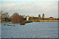
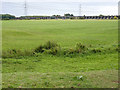
2
Trent Flood
Trent floodplain from Fledborough Viaduct towards Fledborough village http://www.geograph.org.uk/photo/1897982 the primary floodbank has been overtopped, the secondary bank is a long way from the water, but levels are still rising
Image: © Richard Croft
Taken: 10 Feb 2016
0.05 miles
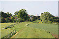
3
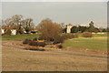
View to Fledborough
View from Fledborough Viaduct towards Fledborough with the course of the old River Trent in the foreground
Image: © Richard Croft
Taken: 10 Jan 2014
0.05 miles
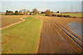
4
Trent floodplain
The secondary western floodbank holding back the River Trent from Fledborough village and St.Gregory's church http://www.geograph.org.uk/photo/3043172 The hedgeline marks a meander in the course of the old River Trent
Image: © Richard Croft
Taken: 30 Dec 2012
0.06 miles
5
Trent floodbank
View north from the viaduct towards Fledborough, 5 weeks after the floods http://www.geograph.org.uk/photo/3276411
Image: © Richard Croft
Taken: 4 Feb 2013
0.07 miles
6
Old course of the River Trent
Looking south from the end of the lane at Fledborough.
Image: © Alan Murray-Rust
Taken: 22 Aug 2014
0.07 miles
7
View towards Fledborough Viaduct
The depression in the foreground represents the old course of the River Trent which now passes through the girder spans of the viaduct.
Image: © Alan Murray-Rust
Taken: 22 Aug 2014
0.09 miles
8
Flood bank
Trent flood bank at Fledborough, seen from the viaduct
Image: © Richard Croft
Taken: 3 Jun 2010
0.09 miles
9

Longest Day
Sunset on June 21st 2010 over the Trent Valley seen from Fledborough Viaduct, view at 9.39pm
Image: © Richard Croft
Taken: 21 Jun 2010
0.10 miles
10
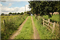
Trent Lane
Track near the River Trent at Fledborough
Image: © Richard Croft
Taken: 15 Jul 2012
0.10 miles