IMAGES TAKEN NEAR TO
The Green, NEWARK, NG22 0TU
Introduction
This page details the photographs taken nearby to The Green, NG22 0TU by members of the Geograph project.
The Geograph project started in 2005 with the aim of publishing, organising and preserving representative images for every square kilometre of Great Britain, Ireland and the Isle of Man.

There are currently over 7.5m images from over14,400 individuals and you can help contribute to the project by visiting https://www.geograph.org.uk
Image Map
Images are licensed for reuse under creativecommons.org/licenses/by-sa/2.0
Notes
- Clicking on the map will re-center to the selected point.
- The higher the marker number, the further away the image location is from the centre of the postcode.
Image Listing (71 Images Found)
Images are licensed for reuse under creativecommons.org/licenses/by-sa/2.0
Image
Details
Distance
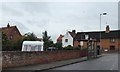
1
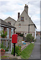
Dunham on Trent postbox, ref NG22 163
Standard EIIR lampbox on post, alongside The Green. An adjacent house formerly housed the village Post Office.
Image: © Alan Murray-Rust
Taken: 22 Aug 2014
0.00 miles
2
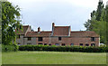
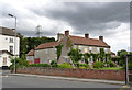
Marples' Cottages, Dunham on Trent
Facing the south side of The Green. The central section with the raised roofline and the section to its left up to the ridge chimney stack date from the early and mid 18th century and are Listed Grade II.
Image: © Alan Murray-Rust
Taken: 22 Aug 2014
0.05 miles
3
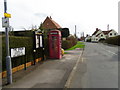
Village street, Dunham on Trent
The historic village of Dunham-on-Trent is named after the Saxon chief Duna, and Ham meaning village.
This street known as The Green has a K6 telephone box and the village noticeboard.
In 1935, the Post Office commissioned a new kiosk from Sir Giles Gilbert Scott to celebrate the Jubilee of King George V. The K6 Jubilee Kiosk, as it is known, was similar to the K2 box, being made of cast iron and painted red but was 25% lighter in weight. By the end of the 1930s there were 20,000 K6 telephone boxes in use all over the UK.
Image: © Maigheach-gheal
Taken: 2 Apr 2011
0.06 miles
4
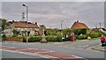
War Memorial on corner of The Green with A57, Dunham on Trent
Image: © Chris Morgan
Taken: 27 Oct 2014
0.06 miles
5
Wilmot House, Dunham on Trent
Late 18th century house, Listed Grade II for group value. Currently a guest house.
Image: © Alan Murray-Rust
Taken: 22 Aug 2014
0.07 miles
6
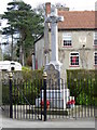
War Memorial, Dunham on Trent
Memorial to the fallen of Dunham on Trent.
We shall remember them.
Image: © Maigheach-gheal
Taken: 2 Apr 2011
0.08 miles
7
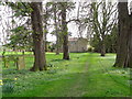
Churchyard, St Oswald's Church
The churchyard contains burials from many generations, showing the Church's concern for its parishioners in this life and beyond the grave. The stones tell the history of the Parish over 200 years and reflect changing attitudes and fashions.
The churchyard here at St Oswalds is large and well kept.
Image: © Maigheach-gheal
Taken: 2 Apr 2011
0.08 miles
8
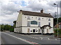
The Bridge Inn, Dunham on Trent
Currently closed as a public house. The building dates from the late 18th century and would have been an important hostelry on the main road to Lincoln near the crossing of the River Trent. Listed Grade II.
Image: © Alan Murray-Rust
Taken: 22 Aug 2014
0.08 miles
9
Bus shelter, Main Street, Dunham on Trent
Image: © David Smith
Taken: 20 Sep 2018
0.08 miles
10
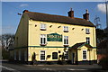
The Bridge Inn
Prominent yellow as you approach Dunham Bridge
Image: © Richard Croft
Taken: 10 Apr 2006
0.08 miles