IMAGES TAKEN NEAR TO
Kneesall Road, NEWARK, NG22 0TR
Introduction
This page details the photographs taken nearby to Kneesall Road, NG22 0TR by members of the Geograph project.
The Geograph project started in 2005 with the aim of publishing, organising and preserving representative images for every square kilometre of Great Britain, Ireland and the Isle of Man.

There are currently over 7.5m images from over14,400 individuals and you can help contribute to the project by visiting https://www.geograph.org.uk
Image Map
Images are licensed for reuse under creativecommons.org/licenses/by-sa/2.0
Notes
- Clicking on the map will re-center to the selected point.
- The higher the marker number, the further away the image location is from the centre of the postcode.
Image Listing (74 Images Found)
Images are licensed for reuse under creativecommons.org/licenses/by-sa/2.0
Image
Details
Distance
2
Fingerpost, Kneesall Road/Main Street, Laxton
Notts C C traditional cast-iron with annulus finial.
Image: © Alan Murray-Rust
Taken: 1 Aug 2014
0.01 miles
3
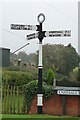
Old Direction Sign - Signpost by Kneesall Road, Laxton and Moorhouse Parish
Annulus finial - 3 arms; Old cast iron, annular finial (NOTTS C C) by the UC road, in parish of Laxton and Moorhouse (Newark and Sherwood District), junction of Main Street, Kneesall Road and Moorhouse Road, on verge.
Surveyed
Milestone Society National ID: NT_SK7266.
Image: © Milestone Society
Taken: Unknown
0.01 miles
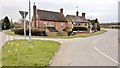
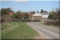
4
Laxton Village approach
Seen from the Kneesall road a large barn full of straw is on the left.
Image: © roger geach
Taken: 1 Feb 2010
0.02 miles
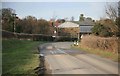
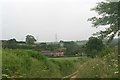
5
Kersall Road
Entering Laxton on Kersall Road
Image: © Richard Croft
Taken: 18 Mar 2011
0.03 miles
6
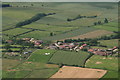
Main Street, Laxton: aerial 2016
For explanation of the Laxton medieval field system and history of Laxton see Image
Image: © Chris
Taken: 24 Jun 2016
0.05 miles
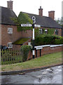
8
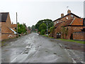
Main Street, Laxton
Looking from Moorhouse Road towards the village centre.
Image: © Alan Murray-Rust
Taken: 1 Aug 2014
0.06 miles
9
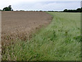
Traditional field boundary, Laxton
As part of the local farming system http://www.laxtonnotts.org.uk/Strip_farming.htm , there is a cereal crop in one part of the field, the other being put to grass for this year.
Image: © Alan Murray-Rust
Taken: 8 Aug 2014
0.06 miles
10
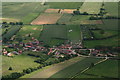
Main Street, Laxton: aerial 2016
For explanation of the Laxton medieval field system and history of Laxton see Image
Image: © Chris
Taken: 24 Jun 2016
0.06 miles