IMAGES TAKEN NEAR TO
Woodcotes Lane, NEWARK, NG22 0TN
Introduction
This page details the photographs taken nearby to Woodcotes Lane, NG22 0TN by members of the Geograph project.
The Geograph project started in 2005 with the aim of publishing, organising and preserving representative images for every square kilometre of Great Britain, Ireland and the Isle of Man.

There are currently over 7.5m images from over14,400 individuals and you can help contribute to the project by visiting https://www.geograph.org.uk
Image Map
Images are licensed for reuse under creativecommons.org/licenses/by-sa/2.0
Notes
- Clicking on the map will re-center to the selected point.
- The higher the marker number, the further away the image location is from the centre of the postcode.
Image Listing (8 Images Found)
Images are licensed for reuse under creativecommons.org/licenses/by-sa/2.0
Image
Details
Distance
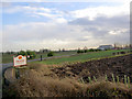
1
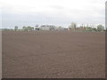
View to Wells Farm
A footpath links where I stand to Wells Farm but it has been ploughed up.
Image: © Jonathan Thacker
Taken: 21 Oct 2011
0.02 miles
3
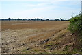
Fields near Wells Farm
Recently harvested.
Image: © Julian P Guffogg
Taken: 23 Aug 2015
0.17 miles
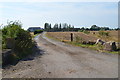
5

Wells Farm
Blocked access road from Green Lane to Wells Farm
Image: © Richard Croft
Taken: 6 Jun 2013
0.19 miles
7
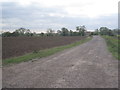
Track to Woodcoates
Woodcoates was a small medieval settlement now just represented by a single farm.
Image: © Jonathan Thacker
Taken: 21 Oct 2011
0.23 miles
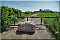
8
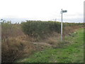
Footpath and bridleway meet Green Lane
The bridleway to Ragnall is passable but the footpath to Woodcoates has been ploughed up.
Image: © Jonathan Thacker
Taken: 21 Oct 2011
0.24 miles