IMAGES TAKEN NEAR TO
Woodcotes Lane, NEWARK, NG22 0TL
Introduction
This page details the photographs taken nearby to Woodcotes Lane, NG22 0TL by members of the Geograph project.
The Geograph project started in 2005 with the aim of publishing, organising and preserving representative images for every square kilometre of Great Britain, Ireland and the Isle of Man.

There are currently over 7.5m images from over14,400 individuals and you can help contribute to the project by visiting https://www.geograph.org.uk
Image Map
Images are licensed for reuse under creativecommons.org/licenses/by-sa/2.0
Notes
- Clicking on the map will re-center to the selected point.
- The higher the marker number, the further away the image location is from the centre of the postcode.
Image Listing (20 Images Found)
Images are licensed for reuse under creativecommons.org/licenses/by-sa/2.0
Image
Details
Distance
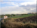
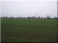
1
Country road nr Majors farm
Once again the old power station cooling towers dominate the view around here.
Image: © roger geach
Taken: 15 Nov 2009
0.07 miles
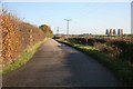
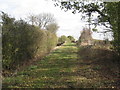
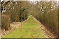
3
Track to Woodcoates
Woodcoates was a small medieval settlement now just represented by a single farm.
Image: © Jonathan Thacker
Taken: 21 Oct 2011
0.13 miles
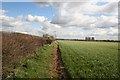
4
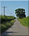
Green Lane
Ancient thoroughfare near Darlton
Image: © Richard Croft
Taken: 19 Feb 2017
0.13 miles
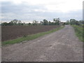
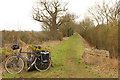
6
Green Lane
Looking towards Woodcoates Road.
Image: © Jonathan Thacker
Taken: 21 Oct 2011
0.14 miles

9
Green Lane
Ancient thoroughfare near Darlton
Image: © Richard Croft
Taken: 19 Feb 2017
0.16 miles