IMAGES TAKEN NEAR TO
York Paddock, NEWARK, NG22 0QX
Introduction
This page details the photographs taken nearby to York Paddock, NG22 0QX by members of the Geograph project.
The Geograph project started in 2005 with the aim of publishing, organising and preserving representative images for every square kilometre of Great Britain, Ireland and the Isle of Man.

There are currently over 7.5m images from over14,400 individuals and you can help contribute to the project by visiting https://www.geograph.org.uk
Image Map
Images are licensed for reuse under creativecommons.org/licenses/by-sa/2.0
Notes
- Clicking on the map will re-center to the selected point.
- The higher the marker number, the further away the image location is from the centre of the postcode.
Image Listing (29 Images Found)
Images are licensed for reuse under creativecommons.org/licenses/by-sa/2.0
Image
Details
Distance

2
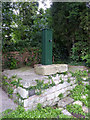
Restored village pump, East Markham
The plaque in the stonework records that this was erected on the site of one of the old village pumps in the year 2000.
Image: © Alan Murray-Rust
Taken: 15 Aug 2014
0.04 miles
3
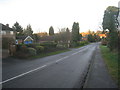
Entering East Markham
Tuxford Road.
Image: © Jonathan Thacker
Taken: 4 Jan 2013
0.05 miles
4
Farm Lane, East Markham
Looking from York Street towards High Street.
Image: © Alan Murray-Rust
Taken: 22 Aug 2014
0.07 miles
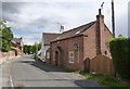
5
Granary, Low Street, East Markham
Retains the remains of the hoist.
Image: © Jonathan Thacker
Taken: 4 Jan 2013
0.07 miles
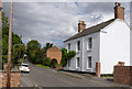
6
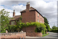
York House, East Markham
Early 19th century house, Listed Grade II.
Image: © Alan Murray-Rust
Taken: 22 Aug 2014
0.07 miles

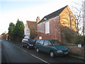
8
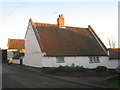
Markham Cottage, Low Street
The building as a whole is spoilt by metal framed windows.
Image: © Jonathan Thacker
Taken: 4 Jan 2013
0.14 miles
9
Wesleyan Sunday School building, Low Street
Now converted to residential use. Dated 1897 on the stone above the porch.
Image: © Alan Murray-Rust
Taken: 22 Aug 2014
0.17 miles
10
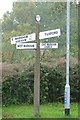
Old Direction Sign - Signpost by Beckland Hill, East Markham
Octagonal finial - 4 arms; Notts CC Octagonal concrete, octagonal cast iron finial (NCC) by the UC road, in parish of East Markham (Bassetlaw District), junction of Mark Lane with Beckland Hill, on verge.
Surveyed
Milestone Society National ID: NT_SK7372
Image: © Milestone Society
Taken: Unknown
0.17 miles