IMAGES TAKEN NEAR TO
Long Lane, NEWARK, NG22 0LS
Introduction
This page details the photographs taken nearby to Long Lane, NG22 0LS by members of the Geograph project.
The Geograph project started in 2005 with the aim of publishing, organising and preserving representative images for every square kilometre of Great Britain, Ireland and the Isle of Man.

There are currently over 7.5m images from over14,400 individuals and you can help contribute to the project by visiting https://www.geograph.org.uk
Image Map
Images are licensed for reuse under creativecommons.org/licenses/by-sa/2.0
Notes
- Clicking on the map will re-center to the selected point.
- The higher the marker number, the further away the image location is from the centre of the postcode.
Image Listing (130 Images Found)
Images are licensed for reuse under creativecommons.org/licenses/by-sa/2.0
Image
Details
Distance
1
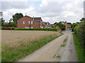
Long Lane, Tuxford
Shown on large scale maps as a road, but its status as a right of way is unclear.
Image: © Alan Murray-Rust
Taken: 15 Aug 2014
0.03 miles
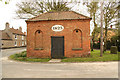
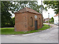
2
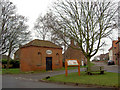
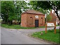
Tuxford Lock Up
Dated 1823, Tuxford was an important staging point on the Great North Road.
After a period of disuse the building was needed again when the railways around Tuxford were being built to lock up the drunken Irish navvies!
Image: © Steve Fareham
Taken: 4 Jan 2008
0.03 miles
3
Tuxford Lock-up
One of the last two lock-ups in Nottinghamshire (the other being at Farnsfield) built in 1823 when Tuxford was a prosperous market town on the Great North Road. The proximity of Sherwood Forest and presence of highwaymen kept the Constable busy incarcerating up to two villains until about 1900
Image: © Richard Croft
Taken: 28 Apr 2010
0.03 miles
4
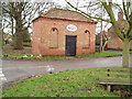
The Village Lockup, Newcastle St, Tuxford
Tuxford was a main coaching stop on the old Great North Road and sometimes suffered from the bad behaviour of those passing through. The lockup was used to contain troublemakers overnight or, for more serious offences, until the magistrate arrived. It is entered by a heavy steel door which leads to 2 separate cells.
Image: © Robert Goulden
Taken: 19 Jan 2006
0.03 miles
5
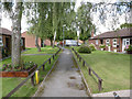
The Pastures, Tuxford
Sheltered housing off Ollerton Road. The path is a designated right of way.
Image: © Alan Murray-Rust
Taken: 15 Aug 2014
0.04 miles
7
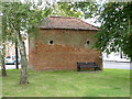
The Old Lockup, Tuxford, rear view
Built to house local miscreants awaiting court appearance. The building is divided into two cells, with a small room for the gaoler immediately inside the main front door. The only light and ventilation for the cell came from the small round opening in the top of the arched panel together with a similar one at the rear. The cells have a vaulted brick ceiling to prevent any chance of breaking out through the roof. Listed Grade II.
There was formerly a later extension to this side which housed the town's fire engine.
Image: © Alan Murray-Rust
Taken: 15 Aug 2014
0.04 miles
8
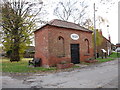
The Lock up. Tuxford
Dates from 1823. The gaoler's room behind the iron door had no direct light whereas the two cells each had tiny lights to north and south. http://www.britishlistedbuildings.co.uk/en-420410-lock-up-tuxford-nottinghamshire#.WDi7FFyq-Tw
Image: © Jonathan Thacker
Taken: 24 Nov 2016
0.04 miles
9
The Old Lockup, Tuxford
Built to house local miscreants awaiting court appearance. The building is divided into two cells, with a small room for the gaoler immediately inside the main front door. The only light and ventilation for the cell came from the small round opening in the top of the arched panel together with a similar one at the rear. The cells have a vaulted brick ceiling to prevent any chance of breaking out through the roof. Listed Grade II.
Image: © Alan Murray-Rust
Taken: 15 Aug 2014
0.05 miles
10
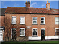
Tuxford - Terrace on Newcastle Street
At junction with Long Lane.
Image: © Dave Bevis
Taken: 30 Jan 2013
0.05 miles